Welcome to my kayak site.
This is a personal page about touristic kayaking. So no information about white water or sea kayaking.
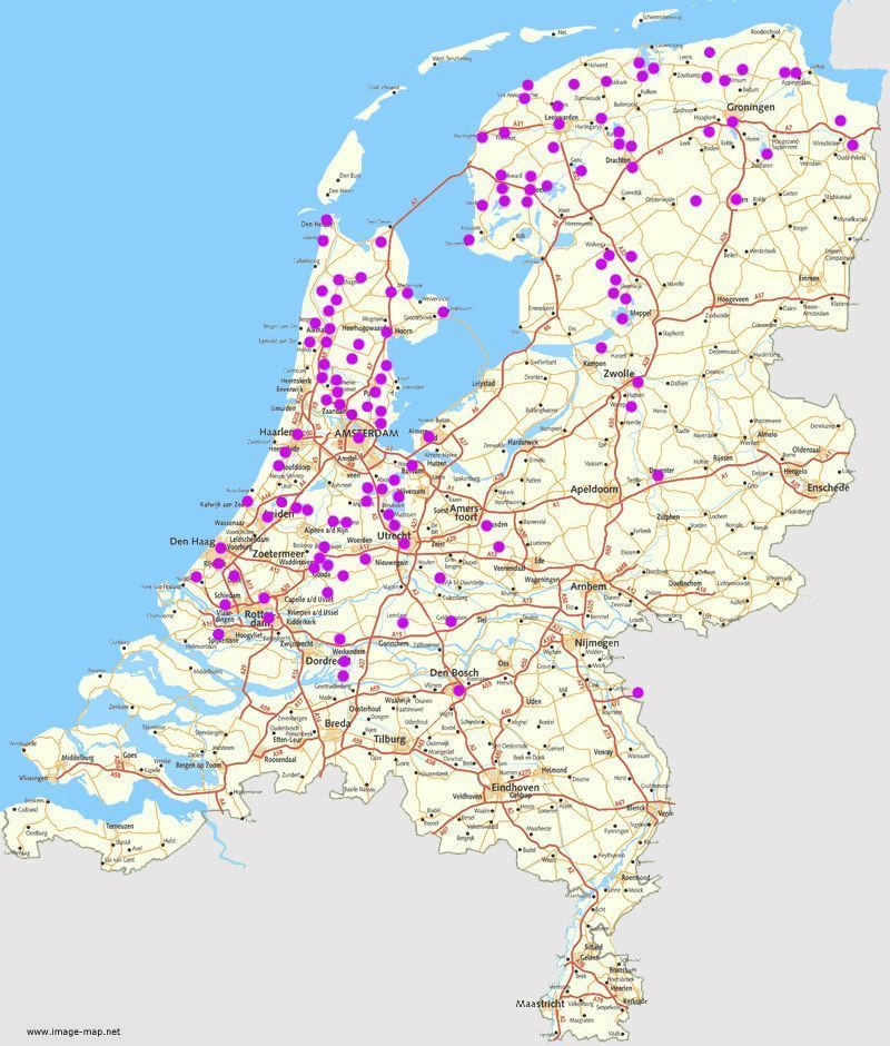
You can read where to kayak in the Netherlands and you can also find information about some places in other countries where I've been.
I like to share the information I gathered over the years. It is not a coverage of all the places where you can kayak, there's still a lot to explore.
So every year I write updates and I still add new pages to the site.
If you may find something incorrect in the described routes, or if you have any suggestions, please let me know. Then I can make corrections so other people can benefit from it.
This site is
copyright protected. If you are interested in using anything from this site, please contact me.
I hope you will enjoy it and that it may inspire you to take your kayak to the water.
I don't rent out kayaks myself! Just to be clear: I only share information about where to kayak. If there is a kayak rental, it is mentioned on the page. You have to contact the kayak-rental yourself, I'm not a middleman.
 kanoweb/kanokaart.nl. A map of the Netherlands with kayak related information.
 weerslag.nl. Information about the actual weather.
 Information about the weather on
weeronline.nl.
 Windy. Worldmap about wind and more.
 TKBN Touristic kayak club of the Netherlands.
 Kayak locations in Belgium (Flanders) on the site of Kajako.
 Air BNB Find a place to stay overnight.
 GPX studio View
and edit a GPX-track on a on-line map.
 GPS Coordinates for calculation between Ddmmss and DDmmmm (decimal minutes).

New on the site:
- The page about Westzaan is renewed. There is a new route of 16 km. with a GPS-track. And all the photo's are new.
- I've been to the Leekstermeer and I discovered some new canals south of the lake. The page has been renewed with a new map. a new description, a new GPS-track, and all photo's are new.
June 2025
- The page about Den Bosch has been renewed. There is a new description about navigating around the city center. There are new photo's and I drew a new map.
- I did the round trip Rondje Linschoten again.
Along the Hollandse IJssel and the Lange Linschoten there are works on the sheet piling.
Sometimes you have to wait a while before you can pass. The Oudewater lock was scheduled to be operable again from April 2025.
Unfortunately, the repairs are still not finished. On the south side is a good floating kayak pier.
On the north side you have to walk a little further and then get in at a stone quay on the right (not convenient because you can't hold on to anything),
or on the left side use a private jetty.
There are new photo's on the site and I drew a new map. - I mentioned earlier that the Blauwe Verbinding between Rotterdam and Barendrecht is completed. I now explored the route from the end near Barendrecht. From here you can make a round trip to the end of the former river Koedood of 13.4 km. The full route to the Zuiderpark in Rotterdam is 2 x 15 km. = 30 km. There is a new map, a GPS-track and there are new photo's of the 13.4 km. round trip.
May 2025
- The page about the Kortenhoefse Plassen is renewed. There are new photo's. Natuurmonumenten has installed new route posts, but the numbers are always 1 higher than before. I drew a new map with more detail, and with the new numbers. Besides the marked route of 9 km. I made an extra round on the lake Wijde Blik. Total distance of this route is 15 km.
April 2025
- October started with nice quiet weather and blue skies. Time to take the kayak to the water again. This time I went to the north of Alkmaar. The page has been renewed with new photo's. I drew a new map and there is a new GPS-track (clockwise this time).
October 2024
- Between De Wieden and De Weerribben you can make a round trip passed the village Nederland. I sailed this round again, and made detours to Dwarsgracht and Blokzijl. The page has been renewed. There is a new map and a GPS-tack. And all the photo's are new.
September 2024
- I did the lower part of the Linde passed Kuinre again. It is a large round trip of 29 km. The page has been updated and a GPS-track has been added. Also there are new photo's
- The page about the river Linde in Friesland is renewed. There is a new map, a GPS-track, and there are new photo's
- A new page about the Bernisse, a nice and quiet waterway not far from the indutrialized Botlek-area.
- I did the trip around the Bergermeer again. There is a GPS-track, and I made a few small additions to the map. All the photo's are new.
August 2024
- From Wehe-den Hoorn you can make a round trip of 13 km. New on the site is a route from Wehe-den Hoorn to Pieterburen. Combined with the round-trip you can paddle 24.4 km. There is a new page with GPS-track, and there are new photo's.
- This site lists two routes that go through Winsum. It has been quite some time ago when I last did the route to the north passing Baflo. So I did this route again, and I made new photo's. I also did the second route passing Feerwerd again. There are new photo's and there is a new GPS-track. It starts at K.V. Winsum, but you can also start at Marenland.
- The page about Zaandam is renewed. There is a better starting point near the Jagersplas. I made a new map of the area including the Oostzanerveld and the recreation area Het Twiske. There is a new route with GPS-track, and there are new photo's.
July 2024
- I did the round trip from Zaandijk again and I made new photo's. The map needed a few mminor ajustments. The title Zaandijk refers to the starting point. The route goes to the north passing Wormerveer, West-Knollendam, Krommenie and Westzaan.
- The page about Zwolle is renewed. There is a new map, a GPS-track and there are new photo's.
June 2024
- The page about Den Helder is renewed. There is a new route to the naval museum with GPS-track. And there are new photo's.
- I've paddled around the Kagerplassen, and the page has been renewed. There is a new route with GPS-track and there are new photo's. I drew a new map that now covers an area to the edge of Leiden.
- In the Wilnis area there are 3 marked kayak routes. I made a trip of 14 km. combining them.
I also did the Kromme Mijdrecht route. I made new photo's, a GPS-track and a new map. - I paddled around the Polder Beetskoog and made new photo's.
May 2024
- On a nice quiet day I paddled from Leerdam to Gorinchem and back on the river Linge. I drew a new map and there are new photo's.
September 2023
- The page about Ezumazijll is renewed. There is a new map, new photo's and a GPS-track.
- The page about Nieuwkoopse Plassen is renewed. There are three marked routes now. I made a trip following most of the tracks. There are new photo's and ther's a new GPS-track.
August 2023
- The page about De Zaan is renewed. I made a round trip on De Zaan and through the polder Wormer. Also it's possible to navigate in the Kalverpolder to the museum area of the Zaanse Schans.
July 2023
- A few things have changed along the river Hunze, so it was time for an update. Many of the old meanders are restored and they make the area very nice for a kayak-trip. But the new nature park Tusschenwater is only partly accessible. A round trip on the canal Leiding 2 is only possible if you don't mind to carry the kayak for 1500 meters on the road. A new GPS-track leads you to and fro on the Hunze.
- A new page with a round trip passed Loppersum.

