

A route of 23.6 km. in the northern part of the Wieden along Wanneperveen and Giethoorn. It is possible to shorten the route.
You have to make this route clockwise, as in Giethoorn there's one way traffic on the canal. You can only pass through Giethoorn in northern direction. Avoid Giethoorn on busy days, as there are many rental boats on the canal and many people are not very good at handling them. In the evening when everything has quieted down it's very nice to pass through Giethoorn.Kayak rentals:
- At various locations in Giethoorn: https://giethoorn.com/varen/kano-kajak/.
- Wanneperveen at the lake Belterwijde: Nijenhuis, Veneweg 199, 7946 LP Wanneperveen.
Starting point Thijssengracht
From Heerenveen: Take exit 7 from highway A32 and follow the N333 in the direction Emmeloord. From Zwolle: take exit 5 from highway A32 and follow the directions to Emmeloord.Outside Steenwijk you turn sharp left just after a bridge. At the canal you turn right on the narrow road. Just before the bridge the starting point is on your right. This is a mooring place for passing motoryachts, but at the bridge there is a small place left where you can launch the kayak if boats are moored.
Starting point Wanneperveen
Take exit 5 from the A32 in the direction Zwartsluis (N375). Then turn right in the direction Wanneperveen. In Wanneperveen you go straight on on the Dominee AC van Raalteweg. After a bend to the left you turn right. At the end of the road (nr 55) you turn right. There is a small boat ramp and there are low sides where you launch the kayak.Round trip 23.6 km from Thijssengracht (GPS-track)
This route is for a large part the same as the marked red route, with an extra loop passing Wanneperveen.Cross the Canal Beukers-Steenwijk and go under the bridge to the Benedenstouwe. Take the second canal to the right. When you come at the lake Bovenwijde you cross it to the south. The lake is rather shallow, it's about one meter deep. In the distance you see a barn. Just a little to the left you come at an island with only a few trees. The island has no name. There are low sides all around it, so you can to the side wherever you like. On the south side there is a swimming area. From the island you head east and enter the canal Paasloërvaart. The entrance is marked with a red triangle. Turn right at the marker with a red arrow. Follow the red arrows and turn left and right again. You're on the Brouwersgaten. Turn left under the bike-bridge. A little further there is a grassfield on the right where you can take a break. There is a small boat-ramp (alternative starting point). Head south on the Haagjesgracht and pass Wanneperveen. Then you turn right under a bridge. The canal bends to the left, and to the right again. Then take the next canal to the right. At the end of the canal you go under a bridge and then turn left. Just after a black barn you turn right. Take the first canal to the left. You pass a small lake with an island. Follow the narrow canal to the Zuideinderwijde. Cross the lake to the north-west. A red triangle markes the entrance of the canal Jonkersgracht. Follow the canal to the north. You pass Zuideinde and Giethoorn. After Giethoorn the canal makes a sharp bend to the right. After the bend you turn left and right again. Follow the canal to the north passing Noordeinde. You come at a lake Molengat. Head north to the short canal. At the junction you turn left. After you cross the Canal Beukers-Steenwijk you're back at the starting-point.
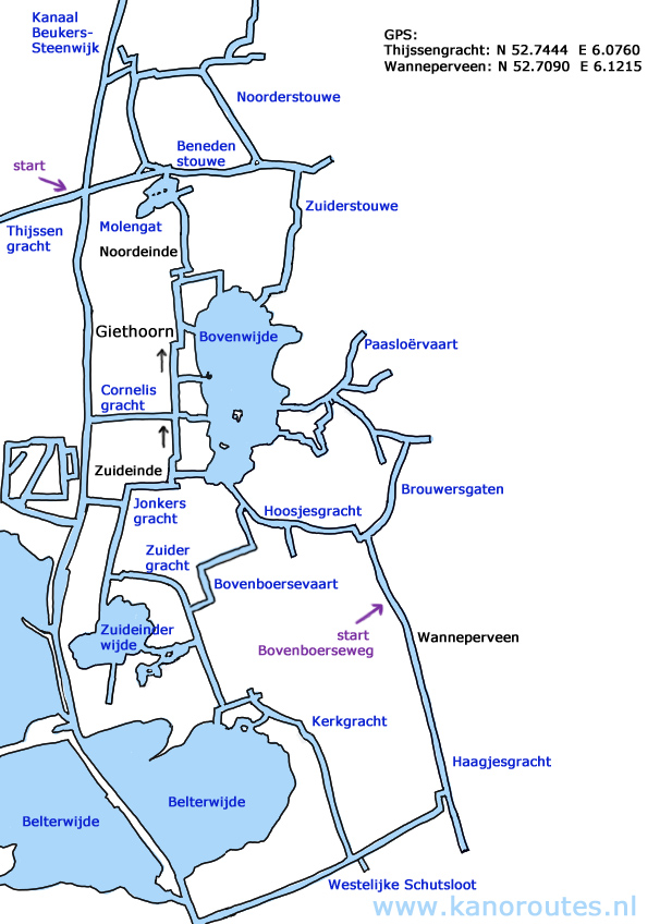
GPS:
Thijssengracht: N 52.7444 E 6.0760
Wanneperveen Bovenboerseweg: N 52.7090 E 6.1215

Downloadable GPS-track (23.6 km): Giethoorn.

Giethoorn Noordeinde.

Giethoorn Noordeinde.

Island in th Bovenwijde.

Island in the Bovenwijde.

Brouwersgaten.

Vieuw on the Brouwersgaten from a bridge.

Wanneperveen.

Giethoorn Zuideinde.

Giethoorn Zuideinde.

Giethoorn.


