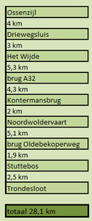
From Ossenzijl you can navigate 28 km. upstream.
The nicest part is between Het Wijde to the Noordwoldervaart (2 x 11,5 km)
Kayak rentals:
De Lindevaarders near the bridge Kontermansbrug (4 km east of Wolvega). Family H. Dedden, Vinkegavaartweg 7, 8474 EB Oldeholtpade, tel: 0561 - 688296.De Linde once came to exist as a glacier river and it ran to the former Zuiderzee.
It had its origin near Oosterwolde, but since the land consolidation in the 1960ties the ditch near Tronde is the official source.
If the water level is good you can still reach this ditch by kayak, but you need to portage a couple of times.
The ditch itself is behind a weir and there is too much overgrowth to navigate on it.
The Linde was of importance in the past as willows and woods were transported from Noordwolde.
The prettiest part of the river is the Lindevallei.
Also the winding part after the Kontermansbrug is very nice.
Starting point at the lake Het Wijde
You leave the highway A32 at Wolvega (exit 8). Follow the signs in the direction De Blesse. In De Blesse you turn right in the direction Oldemarkt. After you passed through Blesdijke you turn right on the narrow Oosterbroekweg. After a bend to the right the road becomes a bike-road. Just before the bridge there is a parking place on the left. There is a mooring place, and on the right side of the pier there is a low part for launching your kayak.From here you go to the right (east), and after 4 km you reach the bridge and a small marina.
A little further on you pass the bridges of the railroad and the highway.
If you go to the side just after the bridges you can see a groundwater level meter. After this you come at the most beautiful part of the Linde.
On both sides there are nature-reserves and a large variety of plants grow along the shore.
There is only a bicycle-road along the river so no traffic-noise disturbs the quietness.
About 4 km further on you come at a bridge named "Kontermansbrug".
A little further on you'll see a white bridge in the distance.
After the bridge there is a barrier to catch herbs. But on the left there is a narrow passage for kayaks.
On the corner of the side-canal Noordwoldervaart there is a kayak-pier.
A little further the course of the river has changed. Work is still in progress (August 2024).
There's now a bend to the right, and then to the left.
Then you come at a weir wit a fish-passage. There are no kayak-piers (yet?).
Many years ago I paddled as far as the bridge of the N353.
There are kayak piers on the way, but access is difficult in the late summer.
You can read a report (in Dutch) by
Suzanne, who was here is in 2022.

GPS:
Het Wijde: N. 52.8462 E. 5.9778
Kontermansbrug: N. 52.8854 E. 6.0698
Noordwoldervaart: N. 52.8897 E. 6.0973

Downloadable GPS-track of 24.2 km.: Linde.gpx.

Bridge at the starting point near Het Wijde.

Linde.

Boathouse near the road Steenwijkerweg.

Railroadbridge, bridge of highway A32, and bike bridge.

View over de Lindevallei seen from the bike bridge.

Remains of a mill in the Lindevallei.


Alternative starting point at the Kontermansbrug.
There are picnic tables. The kayak/canoe rental place is after the bridge.

View from the Kontermansbrug.

View from the Kontermansbrug.

While eating my lunch a small duck kept me company.
On the way back he swam towards me and greeted: "quack quack quack quack".

A new weir is made behind the former locks in the Noordwoldervaart.
Portage is possible.

Kayak pier at the new weir in the Noordwoldervaart.