Passage through Langbroek is closed
Due to works, the passage at Langbroek is closed during the summer of 2023.

A round trip of 24.5 km on the Langbroekwetering, Melkwegse Wetering and Kromme Rijn between Odijk and Cothen.
The route can be shortened by 7.2 km. if you return on the Cothergrift.
The route can be extended by 2.6 km. if you take the extra loop on the Oude Kromme Rijn. It is advisable to make tris trip clockwise as there is more current on the Kromme Rijn than there is on the Langbroeker Wetering. It is not difficult to paddle against the current, but it slows you down.
Kayak rentals:
Paviljoen Buiten, Singel 40 A, 3984 NZ Odijk. Tel.: 030-6624746.De Biologische Boer, Langbroekerdijk A48, 3947 BJ Langbroekerwetering. Tel.: 06-23153685 (Tom Verkerk).
Family restaurant De Jonge Graaf, Graaf van Lynden van Sandenburgweg 2a, 3945 PB Cothen. Tel.: 06-21982306.
Camping:
Camping Strosteeg, Langbroekerdijk 23A, 3972 NC Driebergen-Rijsenburg. Tel.: 06-28570895.To the starting-points Odijk:
Exit the highway A12 between Utrecht and Arnhem at exit 19 towards Wijk bij Duurstede. Turn left at Odijk. The road goes around the village. After 500 meters you turn left on a field next to the scouting. At the end you find a boatramp and a kayak pier. There is a lot of (unpaved) parking space.To go to the starting place at the weir you drive a little further and follow the main road. After a bridge turn right on the Rijnseweg in the direction Langbroek. After the second bump in the road you see the starting-point on your right.
Starting-point on the Oude Kromme Rijn (Molenspoor):
Exit highway A12 Utrecht-Arnhem bij at exit 19 in the direction Wijk bij Duurstede (N229). Exit the N229 towards Culemborg and turn left on the parallel road. After 500 meters you turn right on the Molenspoor. Just after the bridge is the starting point on your left.Note: De parallel road is only open for local traffic. For access to the kayak pier this is no problem in my opinion.
From the starting-point at the weir near Odijk you go to the left. After 4 km. you come at a weir with good kayak piers. A little further is Castle
Sterkenburg. This is private property, and access is not allowed.
A little more than a kilometer further you come at another weir with good kayak piers.
In Langbroek there's another weir. There are no piers and although it's a bit narrow it's not difficult to portage passed the weir.
After the weir you can turn right for a shortened trip on the Cothergrift. If you take this route you need to portage at a fire-station.
There are kayak-piers.
Straight on you pass the estate
Sandenburg. A little further is another weir with good kayak piers.
Then after a short distance you turn right through a culvert on the Melkwegse Wetering.
This is a straight canal towards the Kromme Rijn.
About halfway you pass through another culvert. There is a weir that is usually open. A red light indicates if passage is not possible.
Then you need to portage, but there are no facilities.
At the T-junction you come at the Kromme Rijn.
You turn right and go with the current. There is a park, but it's not accessible because of a wooden rim just below the water line.
There are rims on both sides of the river and they go on for quite some distance, so be careful not to hit them.
You come at the weir of Cothen. There are good kayak-piers here.
About 2 km furhter you can turn left following the original course of the the river the Oude Kromme Rijn.
There is a kayak-pier on the left just after the junction (alternative starting point).
A little further the river and the shortcut join. About 2 km further you come at another weir near Werkhoven with good kayak piers.
Then you see on your right the castle
Beverweerd.
With some efford you can paddle around it and see the beautiful iron bridge.
After the woods the river meanders throught the meadows and you return to Odijk. You see the starting-point on your right.

GPS:
Bunnik Rhijnauen: N 52.0682 E 5.1776
Odijk scouting: N 52.0576 E 5.2316
Odijk stuw: N 52.0509 E 5.2450
Oude Kromme Rijn (Molenspoor): N 52.0094 E 5.2785

Downloadable GPS-track (24.5 km): Kromme Rijn.
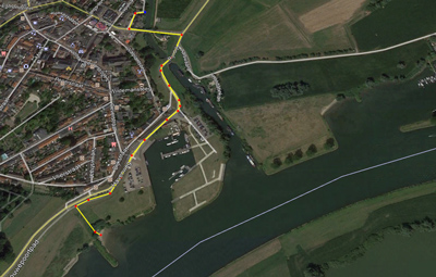
Route for portaging between the Kromme Rijn and the river Lek at Wijk bij Duurstede (800 meters).

Starting-point at Odijk where the Langbroeker Wetering flows into the Kromme Rijn.

Langbroeker Wetering.

Sterkenburg.

Sterkenburg.

Weir in Langbroek. It's a bit narrow, but portage is doable.

Langbroeker Wetering.

Sandenburg.

Gate to the former castle Groenestein.

At the end of the Kromme Rijn there is a kayak pier where you can portage to the river Lek. It's at the end of a narrow dead-end street named Blauwe Pannen.

There is a floating pier in the marina of Wijk bij Duurstede. This is a mooring place, so portage to this place is only possible if there is room. Access is free.

A little further downstream on the river Lek there is a small public beach with access to the dike.

Kromme Rijn near Cothen.

Weir and locks at Cothen.

Ducks also walk around it...

Detour on the meander Oude Kromme Rijn. In the background on the right you see the watertower of Werkhoven.

Pumping station at the end of the Caspergouwse Wetering. There is a picnic table, but unfortunately there's no kayak pier (I was here on a bicycle-trip).

Portage at the weir near Werkhoven. There are good kayak piers.

Beverweerd.

You can navigate around the castle and pass under the beautiful iron bridge.

A good starting point next to the Scouting Odijk along the Singel
(on the other side of the river).
There is a kayak pier and a boat-ramp. Lots of free parking space.

Bunnik.
Under the narrow bridge the current increases.

View over the side-arm towards the estate Nienhof in Bunnik.

Swans nest on the Hakswetering.