

From the
Chain Bridge Hotel in Llangollen to the Pontcysyllte Aqueduct and back is 2 x 10.7 km = 21.4 km. (no portages).
To the Chirk Aqueduct is 2 x 15.6 km = 31.2 km (no portages, 2 long tunnels).
No kayak rentals.
Camping near Llangollen:
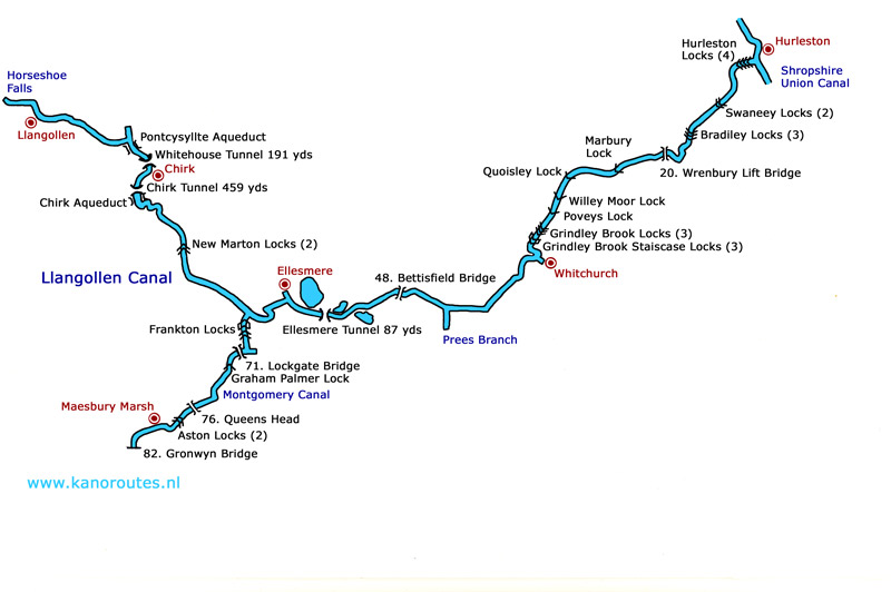
A campsite close to the starting point is Abbey Farm. In the centre of Llangollen you exit at the traffic lights in northern direction. After a bridge you turn left. The camp-site is 3 km from the center of Llangollen on your right. Tel.: 01978-861297.The Llangollen Canal has a length of 73.5 km and runs from Horseshoe Falls, just east of Llangollen, to Hurleston Junction, where it ends at the Shorpshire Union Canal. There are 21 locks (most of them in the eastern part), 3 tunnels, 49 numbered bridges and two large aqueducts.
Starting point Chain Bridge Hotel:
Parking at the hotel is for residence only. You can drop your kayak here and park further uphill. From the free parking place there is a footpath downhill and you take the iron stairs down to the starting place at the feeder of the Llangollen Canal. A walk from Abbey Farm is about 1 km.This certainly is the most spectacular part of the canal. The canal begins very narrow (meant only as a water-feeder) with rocks rising straight up from the water. From Llangollen the canal is navigatable for narrow-boats, but it still is very narrow. Just after bridge 31, the canal turns sharp to the right and there you see the Pontcysyllte Aqueduct right in front of you. It was built 200 years ago and it carries the canal 38 meters above the river Dee. It is very impressive. From the kayak you can look over the edge. At km 11.5 you meet the first tunnel, the Whitehouse Tunnel (175 meters). You must a water-proof forward shining light attached to the deck of the kayak, and a whistle to warn any approaching boats from the other side that you enter the tunnel. At km 8.5 is the considerably longer Chirk Tunnel (420 meters). Kayakers officially are not allowed to enter this tunnel, so you better take the towpath that also runs through the tunnel (but is very narrow).
The Chirk Aqueduct is just outside the tunnel. It has a heavy stone structure, and a railroad-bridge is situated next to it.
GPS Chain Bridge Hotel: Lat. 52.9825 Lon. -3.1909
GPS Pont Cysyllte Aqueduct: Lat. 52.9719 Lon. -3.0896
GPS Frankton Junction: Lat. 52.8802 Lon. -2.9365
GPS 71 Lockgate Bridge: Lat. 52.8729 Lon. -2.9396
GPS Queens Head (road A5): Lat. 52.8355 Lon. -2.9823
GPS Bettisfield Bridge: Lat. 52.9144 Lon. -2.8052
GPS Whitchurch: Lat. 52.9693 Lon. -2.6995
GPS Grindley Brook Staircase Locks: Lat. 52.9817 Lon. -2.7104
GPS 20 Wrenbury Liftbridge: Lat. 53.0281 Lon. -2.6128
GPS Hurleston Locks: Lat. 53.0916 Lon. -2.5676

Horseshoe Falls, where the Llangollen Canal begins.

Starting point at the Chainbridge Hotel. Unload your kayak here, park uphill and return decending the iron stairs.

Llangollen.

The canal is very narrow near Llangollen. Give way to the narrowboats.


Whitehouse Tunnel (191 meters).

Pontcysyllte Aqueduct.

Pontcysyllte Aqueduct.

View from the Pontcysyllte Aqueduct.

Chirk Aqueduct.

Chirk Aqueduct.

Chirk Tunnel (450 meters).

Chirk Tunnel.

