

Two routes:
Round trip of 26.5 km from Gytsjerk.
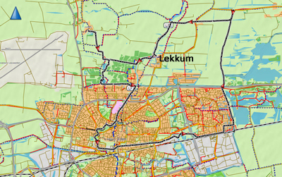
One portage, but it can be skipped if you take a shortcut.Round trip of 23 km from Lekkum.
One portage if you choose to pass throught the Leeuwarder Bos.
No kayak rentals
Round trip of 26.5 km from Gytsjerk.

Downloadable GPS-track (26.5 km) from Gytsjerk: Leeuwarden1.
To the starting point Gytsjerk
Follow the signs to Leeuwarden Noord. Take the N355 in the direction Buitenpost. At traffic-lights you turn left on the N361 in the direction Gytsjerk. After 2 km. you turn left. A little further there is a boatramp with a kayak pier on your left. This is property of Stichting Watersport Trynwâlden, but there is free access to the kayak pier.Round trip of 26.5 km. according to the GPS-track.
From the starting point you go left passed the small marina. Follow the bend to the right and follow the wide canal. After a bend to the left you come at the lake Sierdswiel. You cross the lake. The entrance of the canal is marked by a triangular sign. Follow the right side of the lakes Houtwiel and Grutte Wiel. Turn right on the canal, and when you come at a T-junction you turn left on the Alddeel. Turn left under the bridge "Hoge Brug". You can go straight on passed Camminghaburen, or turn left at the next junction for a detour on the Nieuwe Wielen. There are four small lakes. There are narrow passages between them. But to the last lake there is a dike and you need to portage here. There are good kayak piers, but they are overgrown by reed and difficult to reach (situation July 2020). Once back on the Alddeel you continue south and turn left under a bridge and then right. After a while the canal bends to the left and you pass an industrial area. You keep going straight on. After a footbridge you come at a T-junction. You turn right here on the Wide Greons. After a small distance you turn left on the Potmarge. This is a green area with some houseboats and parks. There is a side-canal to the left that leads to Huizum. If you enter the canal you pass a kayak pier at the church. Because of the trees you don't see much of the church though. At the end of the Potmarge you cross the Nieuwe Kanaal and you can explore the canals in the city center. In the north there is a sign that directs towards Dokkum. Follow the Dokkumer Ee. After some distance you take the second canal to the right. There is a sign saying "Bonke". Follow the Bonkevaart to the end. At the T-junction you turn left, and a little further to the right again. You pass the lakes Grote Wielen back to the starting point.Round trip of 23 km from Lekkum to Jelsum and the Leeuwarder Bos.
Downloadable GPS-track (23 km) from Lekkum: Leeuwarden2.
To the starting point Lekkum
Follow the signs to Leeuwarden Noord. Take the N355 in the direction Buitenpost. At traffic lights you turn left in the direction of Lekkum. In the village you turn left on the narrow street Ieborchpaed. Take the second street to the right and then turn left. At the end there is a boatramp with a kayak pier. Don't park at the turning point. Along the Dokkumer Ee there is a small park with picnic tables.Round trip of 23 km. according to the GPS-track.
From the starting point you turn left on the Dokkumer Ee. Then you turn right under the liftbridge on the Jelsumer Feart. At a farmhouse you turn right. This side-canal still is the Jelsumer Feart. Just before Jelsum there is a mooring place. From here you can walk to the village. There is a dead-end canal to the village, but you can't go to the side there. There is room to turn around. You go back and at the farmhouse you turn left. For a visit of the forest Leeuwarder Bos you turn right. You pass a few small lakes and you keep left. At the last lake Taniameer there is a small camping Taniaburg. You can turn back here, but if you don't mind to portage (200 meters) you can enter a narrow passage on the right. Then you turn left on the straight canal. Just before the end of the canal you turn right under a bridge and then left again. At the end of the canal you can go to the side. There's no kayak pier, but the side is low so it's not difficult. You carry the kayak to the right and you turn left on the bike-road. The canal on the left leads to the Dokkumer Ee, but it is closed by a beam. So you have to walk a little further to the Dokkumer Ee. You can enter the canal here, or 100 meters further there is a low fishing-pier.You turn right on the Dokkumer Ee towards Leeuwarden. You can pass through the canals, but the GPS-track leads around the city center. You turn right on the Noorderstadsgracht and the Westerstadsgracht. You pass the leaning tower Oldehove. When you come at a big junction you turn left on the Nieuwe Kanaal. You pass the former prison that is a museum now. You pass a few factories and then you turn left under the high voltage lines. Then you turn right on the Kurkmeer. After 1.5 km. you can turn left for a small passage through Camminghaburen. You turn right again and you come at the main canal Alddeel. Here you turn left and head north. You keep going straight on. After a bridge (road N355) you turn right. Follow the bend to the left. You can continue to the Kanterlandse Brug. This bridge is a monument of the skating-tour Elfstedentocht. Just before the bridge you turn left on the Miedumer Diep. You pass the village Miedum, but as it's not directly along the canal you don't see it. At the end of the canal you come at the Dokkumer Ee. You turn left and head back to the starting point Lekkum.


Nije Wielen. There are two small bridges between the lakes.
To the third lake you need to portage. There are kayak piers, but there's a lot of reed (2020).

Waldmansdjip.

Wharf at the Wilde Greons.

Huizum.

Potmarge.

Nieuwe Kanaal.

Prison Museum along the Nieuwe Kanaal.

Church St. Bonifatiuskerk.

City center.

Westerstadsgracht.

Oldehove.

Naauw.

Grote Wielen.

Starting point Lekkum.

Pass under the liftbridge to the Jelsumer Feart.

End of the Jelsumer Feart with the bridge to the Dekema State. There is room to turn around.

Jelsum.

Camping Taniaburg along the Tania Meer.

Leeuwarder Bos.


 A sign to encourage people to slow down in the city.