

Two routes:
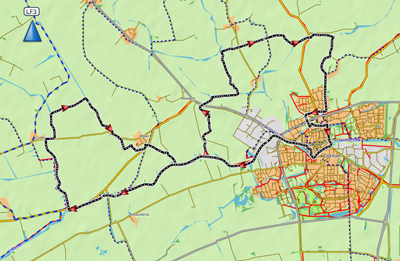
Round trip of 28.5 km.
Various portages, one of them is 300 meter.Round trip of 22 km. passed Raard and Dokkum.
Three portages.
Kayak rentals:
Schreiershoek Recreatie, on the road to Oostrum. On Sunday only after reservation: Tel.: 0519 242183.Starting point at the bridge Klaarkampsterbrug:
From Leeuwarden go east on the N355 and turn left at traffic lights on the N361 towards Gytsjerk and Dokkum. When you come at a roundabout where you can turn right towards Rinsumageest, you turn left on the road named Trekwei. At the T-junction you turn left, and right again. You cross the bridge on the Dokkumer Ee, and on your left you find a suitable place to put the kayak into the water.Starting point Zaagmolenstraat:
There is a small boat ramp opposite the church Gemeentecentrum De Poort. That is where the Vrije Baptistengemeente Nehemia is located. On Sunday-morning there is limited parking space.Take the northern beltway around Dokkum (N356). At the roundabout where the N356 leads towards Holwerd you go straight on and turn left a little further on the Feije Van Heemstrasingel. Turn left on the Zaagmolenstraat. At the end of the road is the starting point.
Starting point along the Paezens near Aalsum
Take the northern beltway around Dokkum (N356). At the roundabout where the N356 leads towards Holwerd you go straight on. At the next roundabout you turn left in the direction Hantum. After 1.8 km. you come at a bridge. The starting point is just before the bridge on your right. There is a picnic table and a small field. There is a good kayak pier.
Round trip of 28.5 km.
Starting point at the Klaarkampsterbrug.

Downloadable track: Dokkum 28.5 km.
You head east to Dokkum. At the fortress you see a huge windmill. You turn left on the Driepypstergracht.
You navigate around the fortress. On you right you see a kayak-pier that marks the entrance of a narrow canal.
Once you enter the canal there's no turning back because it is too narrow.
The canal is named Kereweer, Kloostersingel and the last part is named Westersingel.
It is very beautiful, but at the end there is a gutter which you have to take to go to the Kleindiep.
Portage is not possible. The idea is you glide down with your kayak.
WARNING: This is for the daring.
If your kayak has a V-shaped bottom you better don't go because it's likely you turn over.
You can pass the portage place and turn right on the Grootdiep. Further on the canal is named Kleindiep.
Turn right on the Driepypstergracht again. Around the first tip of the fortress you turn left.
You have to portage at the locks. They are no longer in use.
At the next T-junction you turn right on the main canal Aalsumervaart.
The canal goes around the former mound Aalsum. Only the church in the center remains.
At the next junction you turn right on the Paezens. This is a very quiet canal with meadows on both sides.
At the next junction you turn sharp right on the Jellegat.
After a short distance you come at a weir where you have to portage.
On the right you can go to the side. You go under the electric fence and pass through the wooden gate.
You cross the bridge and the road. You find a low side where you can continue.
When you come at the Zuider Ee you turn left, and right again on the Oostrumer Opvaart.
A sign indicates this is a dead end canal, except for kayaks.
At the end of the canal there is a low side where you can get out.
There may be cows walking around. They are just curious, and they mean no harm.
You walk to a dam in the ditch and go around the gate.
At the next field you walk along the barbed wire and bushes. In the corner there a gate where you can go to the bike-road.
You cross the bike road and in the corner of the inlet there is alow place where you can go to the Dokkumer Grootdiep.
You turn right and pass the former stone factory Oostrum.
There is an impressive chimney, but it's in terrible shape (2021).
There are plans to restorate the factory as it is a national monument.
When you come at Dokkum you turn left and follow the main waterway around the south side (Zuidergracht and Baantjegracht).
When you are at the windmill you can turn right for another trip throught the city center.
In the afternoon the light is better for making photo's in this direction.
You can also turn left on the Dokkumer Ee to shorten this trip.
For the complete route of 28.5 km. you go straight on on the Driepypstergracht (again).
You turn left and portage passed the locks.
Then at the next junction you turn left on the Verbindingskanaal.
After a long culvert you turn right on the Oude Paezens.
You pass the alternative starting point with a small boat-ramp at the end of the Zaagmolenstraat.
At the next junction you turn left on the Foudgumervaart.
There are many bends. You come at a pumping station where you need to portage.
There are good kayak piers here. A little further you come at the Dokkumer Ee.
You turn right here to return to the starting point.

Portage between the Oostrumer Opvaart and the Dokkumer Grootdiep (300 meter).
Raard and Dokkum (22 km)
Starting point Klaarkampsterbrug
Downloadable track: Raard-Dokkum 22 km.
From the starting point you go west (away from Dokkum). After a short distance you turn right in the direction Holwerd. At the village Lichtaard you go under a bridge and follow the bend to the right. There is a pier on your right also suitabel for kayaks. When you come at a T-junction the main canal Holwerdervaart goes to the left, but here you turn right. After a few bends the canal ends at a road. You need to portage here, but there are no facilities. You can get out on hte concrete of a low culvert. On the other side of the road the culvert is of no use because it's in a corner of the canal. The best place to continue is from the field on the other side of the canal. The canal Raardervaart continues passed the village Raard. You pass through a low culvert. After a short distance you come at the Dokkumer Ee. You turn left, and left again on the next side-canal the Foudgumervaart. After a short distance you come at a portage-place with a small pumping station. There are kayak-piers. At the next junction you turn left, and right again on the main canal. After a short distance you turn left on the Hantumervaart. After an old bridge that's no longer in use you turn right on the Paezens at the next intersection. You follow the main canal. After a bridge there is a kayak pier on your right wit a picnic-table. This is the alternative starting point. At the next intersection you turn sharp right on the Aalsumervaart. After a bend to the right you turn left. You come at locks that are no longer in use. There are good kayak piers so portage passed the locks is no problem. You turn left on the Noordergracht and follow the main canal around the city center. After the first windmill you turn right on the narrow canal Wortelhaven. After two bends you come at the Kleindiep in the center. You turn left here. You go straight on and follow the Dokkumer Ee for 3.5 km. back to the starting point.

GPS Klaarkampsterbrug: N 53.3158 E 5.9350
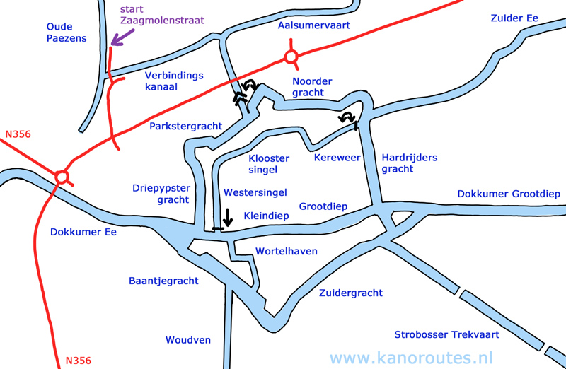
GPS Zaagmolenstraat: N 53.3300 E 5.9904
Warning: dangerous gutter between the Westersingel and the canal Kleindiep!

Starting point at the bridge Klaarkampsterbrug.

Kloostersingel.

Westersingel.

At the end of the Westersingel there is a gutter to Het Kleindiep.
Not for the unexperienced. If you have a kayak with a V-shaped bottom (like I have), you better don't try.

Locks to the Aalsumervaart.

Along the Paezens.

Along the Paezens.

Oostrumer Opvaart.

At the portage pont to the Dokkumer Grootdiep.
There is a low side in the corner of the former harbor.

Stone factory with a topped off chimney.

Stone factory 2021. There are plans for a complete restoration.

Baantjegracht south of the city center.

Windmill seen from the Dokkumer Ee.

Het Kleindiep.

Het Grootdiep.

Raard.

At the portage point in the Foudgumervaart.

Kayak pier along the Paezens near Aalsum.

The Wortelhaven in Dokkum.

 The entrance of the Ostrumer Opvaart. "Dead end canal. No entrance.
Except for kayaks."
The entrance of the Ostrumer Opvaart. "Dead end canal. No entrance.
Except for kayaks."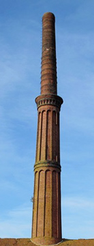 Photo from 2010.