The Thames has a length of 346 km. (216 miles). On this page you only find information about the Oxford area and further upstream around Lechlade. As far as I know Oxford is the only place in the UK where you can navigate a round trip on one day. It's named the Oxford Circuit. There are various other streams around Oxford where people kayak, but you need a special white water kayak for that.
Kayak rentals:
Thrupp Canoe and Kayak Hire Centre, Canal Yard Canal Road, Thrupp, Kidlington, Oxon OX5 1JZ, Tel: 01865 376176.Kayak tours:
Oxford Kayak Tours, tel.: 07816 6553701. Het Oxford Circuit: een round of 12,6 km.
Starting point at Wolvercote:
Actually there's only one place where you can park along the water and have good access for launching a kayak, at the parking place in Wolvercote. There is plenty of free parking space and public toilets. Just mind the hight barrier of 2.2 meters. I just could go under it with the kayak on the roof, but with an SUV you won't.From the starting point you go downstream. On your left you see Port Meadow, a common grazing ground since 1086. Keep to the right side of there are rowing boats. When you come at a marine keep to the right and go under the round bridge. A little further on you come at an intersection. To the right (a bit hidden under the trees) is Osney Stream. There is a chain across the water, but you can pass it. Take the boat out at the weir. After the weir is a place that was a swimming pool until 1990 named Tumbling Bay. It is a beautiful place for a (lunch)break. If you go straight on you come after a short distance at the lock Osney Locks.
The Oxford Circuit goes to the left under the white round bridge. After a railroad bridge you see Isis Lock that brings you to the Oxford Canal. After Isis Lock you go straight on and follow the Oxford Canal. It mostly goes passed the city and you only see some back-gardens of the houses. After Wolvercote Lock you go under the highway, and then turn left into Duke´s Cut. You pass Duke´s Lock and then turn right. Keep right and then turn left to King´s Lock. This is a very nice place. There is a shelter, and information about the area is available. At the lower side of the lock is a floating platform where you can launch the kayak. If you´re lucky you can pass through the lock with another boat. After the lock there are a few sharp bend in the river. After you went under a highway bridge you keep right and you come at Godstow Lock. On the right side are the remains of Godstow Nunnery. After the locks you turn left to the starting point.
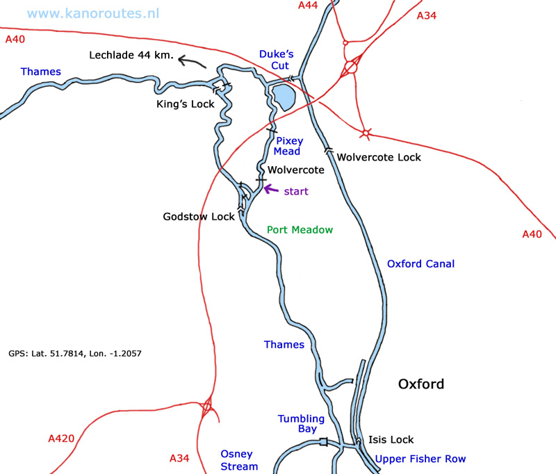
GPS Wolvercote: Lat. 51.7810 Lon.-1.2959

The Thames.

Oxford.

Oxford.

Tumbling Bay.

Isis Lock.

Oxford Canal.
2. The Thames at Lechlade.
Canoe rentals
Open canoes ad kayaks at Cotswold Canoe Hire in Lechlade.Starting point St. John's Lock:GPS: St. John's Lock: Lat.: 51.6889, Lon. -1.6793
At St. John´s Lock there is a layby on the road where only a few cars can park. It is on Lechlade Road (A417) from Lechlade in the direction Faringdon.As an alternative you can drive a little further towards Faringdon. On your left there is a picnic area where you also can launch a kayak. Local people also go here to kayak on the river.
From Lechlade you can go downstream. There are almost no houses or roads near the river, so you can enjoy the nature and the silence. Some distances downstream from St. John´s Lock: Buscot Lock 1.8 km; Grafton Lock 7 km; Radcot Lock 10.5 km; Rushie Lock 14.2 km; Tadpole Bridge 15.5 km.
Upstream you pass the Half Penny Bridge at Lechlade. After the marina you will seldom see another boat. Officially the Thames is navigatable till The Round House. This is where the river Coln joins the Thames (no access) and. The Round House was the lock-keepers house for the locks to the former Thames Severn Canal. Here the river becomes narrower and there is more current. With some efford, af if river conditions allow it, you can go upstream as far as Hammington Bridge near Kempsford. It is really beautiful to go there. You really get a wilderness feeling and see a lot of kingfishers. Distances upstream form St. John´s Lock: Lechlade (Half Penny Bridge) 1 km; The Round House 2 km; Hammington Bridge 7.7 km.

St. John's Lock near Lechlade.

Downstream of Lechlade.

Thames.

Thames.