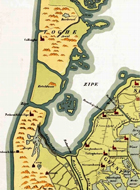
Round trip of 22.7 km. on the Noordhollands Kanaal and Groote Sloot.
Two portages at the ponton bridges.No kayak rentals.
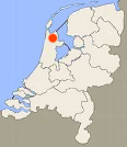
Starting point at the war monument at Zijpersluis
A good starting point is the war monument at Zijpersluis. Take the N9 from Alkmaar towards Den Helder. A few kilometers north of Schoorldam you take the first exit to the left and continue north on the access road. Across the bridge you turn left. There is parking space and a picnic table at the war monument.From here you go under the bridge and cross the Noordhollands Kanaal
and you pass the former locks Jacob Claesse Sluis to enter the
Groote Sloot. Then comes the long stretch towards Schagerbrug.
This is a quiet canal with a charm of its own. Just after Schagerbrug you turn left
on the Schager Kanaal.
Just before you reach the Noordhollands Kanaal you can enter the
side-canal to the right and have a break at the Avia fuel station.
They serve coffee and snacks and there are toilets available. At
the third bridge there is a low side and you can walk to the fuel
station without crossing any roads.
When you reach the Noordhollands Kanaal at De Stolpen, turn left again. Keep to the sides when ships pass by and be prepared to meet some waves.
You can pass the ponton-bridges with another ship if you're lucky. Be quick as the bridges are remotely controlled and they don't stay open for canoes.
If no ships are coming you don't need to wait. First be sure the bridge is not going to open. Then go under it at the sides.
There is a big double log floating in the water on the south side of the bridge. You can stand on it and pull the canoe across.
Be careful, it is slippery when wet. After Burgervlotbrug you see a number of new windmills on you left and then you reach Zijpersluis.
You can make an extra trip on the Hondsbossche Vaart along the Schoorlse Zeedijk
towards the present sea dike near Petten.

Downloadable GPS-track (22.7 km): Zijpe.

GPS Zijpersluis: N. 52.7329 E. 4.6886.

War monument at the starting place Zijpersluis.

Starting point at the monument Zijpersluis.

Former locks at Zijpersluis.

Burgerbrug.

Monument 400 years Polder Zijpe. It is a wooden frame of a traditional farmhouse.


View from the monument.

Schagerbrug.

"Twee Zwanen" (Two Swans) at De Stolpen.

Sint Maartensvlotbrug.

Noordhollands Kanaal.

Portage across the double wooden beam at Burgervlotbrug.

Zijpersluis.

The end of the Hargervaart.
There's no kayak pier, but out of the high season there are places where you can go to the side.
You can have lunch or a drink at
Restaurant
Duingroet.

View on the Hondsbossche Zeewering from the dike along the Hondsbossche Vaart.