

Round trip of 22.5 km to Hindeloopen:
You can navigate on the IJsselmeer or choose to follow the canal behind the dike (23.5 km).Camping and kayak rentals:
Camping Het Séleantsje, 't Séleantsje 2, 8722 HE Molkwerum. Tel.: 06-13457532.Starting point Stavoren:
The starting point is at the parking along the Stationsweg just outside the town. There is a super market (Coop Stavoren) a little further across the bridge.From the Afsluitdijk you follow the A7 and exit at Bolsward on the N359. You pass Koudum and the aqueduct Galadammen. There is a harbour and recreation area, but you can't launch a kayak here. After the aqueduct you go straight on at the roundabout and then at the next intersection you turn right. You pass Hemelum. In Warns you turn right at the T-junction. After the bridge across the Johan Willem Frisokanaal you turn left on the Noardermar towards Stavoren. Follow the bend to the right and before the railroad crossing you turn left. After a short distance you see the parking lot on your left. There is a small boat ramp, but no kayak pier. About halfway I found a suitable place to launch the kayak.
From the south you exit the A6 at Lemmer and turn left on the N359. In Balk you turn left. The after 7.4 km you turn left towards Warns. You pass Hemelum. In Warns you turn right at the T-junction. After the bridge across the Frisokanaal you turn left on the Noardermar towards Stavoren. Follow the bend to the right anf before the railroad crossing you turn left. After a short distance you see the parking lot on your left. There is a small boat ramp, but no kayak pier. About halfway I found a suitable place to launch the kayak.

Downloadable GPX-track: GPS/Stavoren.zip (unpack and open with Garmin Basecamp or other program).
Mapmyfitness:
http://www.mapmyfitness.com/routes/view/403001250
Round trip of 22.5 km.
From the starting point you go to the left. Follow the bends to the left under the railroad bridge. At the dike of the IJsselmeer the canal bends to the right. After a short distance there is a mooring place on your left. You can take your kayak across the dike and continue on the IJsselmeer here, or a little further at the second mooring place where the canal gets wider. The IJsselmeer is big water and much depends on your equipment, skills and weather if you should go there. As an alternative you can keep on the canal behind the dike. The distance is about 1 km extra because of the bend in the dike. On the IJsselmeer you turn right and navigate parallel to the dike. Afer a short distance the dike makes a bend to the right. Straight ahead is a bird reservation and you're not allowed to navigate there. It is marked with red/white buoys. So from here you set course on 010 in the direction of the church tower of Hindeloopen. You pass the buoys and after the last one you can turn slightly to the right. You see a white building on the dike, and you head for the small beach just after it. There is a row of poles in the water. Here you portage across the dike towards Camping Hindeloopen. There is a good launch place at the entrance of the camping. You head east passed the camping, and the turn left for a visit of Hindeloopen. In Hindeloopen you can turn right towards the locks or go straight on. If you go straight on you can go as far as the next side-canal to the right just before the church. You must turn back here as the canals become very narrow and they are dead ends.On the way back you follow the main canal (Indijk). You go under the railroad bridge and from there it's 2.8 km. to the next intersection. You turn right here and follow the canal named De Gronzen along the road towards Molkwerum. At the railroad bridge there is a restaurant with a floating kayak pier: 't Stasjons Kofjehús. In Molkwering the main canal bends to the right, but you go straight on under the bridge on the canal named Fenke. After the church the canal bends to the left. After 1.7 km you come at the Johan Friso Kanaal. You turn right towards Stavoren. Before the locks you turn right. At the end of the town the canal bends to the right and you're back at the starting point
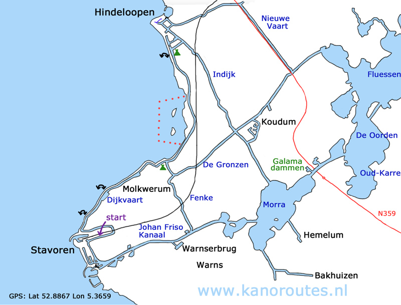
GPS: Lat. 52.8867 Lon. 5.3659

Portage to the IJsselmeer.

Portage to the IJsselmeer.

Back on land near Hindeloopen.

Hindeloopen.

Hindeloopen.

Hindeloopen. Turn back here as the canals become narrow and they are dead ends.

Hindeloopen.

Hindeloopen.

Thunderstorm along the Indijk Kruisvaart.

Molkwerum.

