- Route of 28.4 km passing Oldeboorn and De Deelen of 28,4 km. No portages.
- Route of 20.0 km. passing Grou. No portages.
Kayak rentals and camping along the canal:
Drijfveer And Tusken De Marren, Ulbe Twijnstrawei 31, 8491 CJ Akkrum. Tel.: 0566 - 652789Starting point at the Boarnsterdyk in Akkrum:
Exit the A32 between Heerenveen and Leeuwarden at Akkrum (N392). Turn left towards Akkrum and the at the T-junction you turn right on the Boarnsterdyk. The starting point is on your left just after the bridge towards Nes. There are boats moored here, but there's always a place nearby where you can launch the kayak.
Starting point camping and kayak rental Drijfveer And Tusken de Marren in Akkrum:
Exit the A32 between Heerenveen and Leeuwarden at Akkrum (N392). Turn left towards Akkrum and the at the T-junction you turn left. The road goes under the highway and the railroad. In the village you turn right at the T-junction on the Kleef. Follow the bend to the left and you cross a bridge. After you see the Coopersburg on your right you turn left (before the bridge). You pass a bridge and you see the camping and harbour on your right.
Route of 28.4 km passing Oldeboorn and De Deelen of 28,4 km.
No portages.
From the Boarnsterdyk you go to the right (south) on the Boorne.
After 3 km you come at the village Oldeboorn. The canal narrows and there are a few low bridges, that you can go under.
After the village the canal bends to the left and it goes straight for 1.7 km.
From the next bend the canal is named Nieuwe Diep (New Deep). The Ouddiep (Old Deep) is not accessible.
You can see a farmhouse in the distance (photo at top of the page), where you turn sharp right.
This canal is named Stroomkanaal. It is very quiet as there are no houses or roads nearby. You just hear silence and birds.
You pass the disused pumping station Tripgemaal. At the end of the canal you turn right.
This is a long straight canal. As it passes the nature park
De Deelen, you can see and hear many birds.
On the right you see numerous fishing piers made of concrete. Unforunately nobody thought of kayakers here, so there's no kayak pier.
With some efford you can go to the side and see the Deelen across the bike road.
After dozens of fishing piers the canal bends to the right and is named Nieuwe Pompsloot.
On your left you see an old wooden ship on the side. This was used for transport of the peat from the area.
After the bridge of highway A32 you turn right at the T-junction near the railroad on the Monikerak.
The canal bends to the left and you go under the railroad.
At the T-junction you come at a main canal that connects Heerenveen to the other main waterways.
You turn right on the canal named Het Deel.
After 2 km. you pass the footferry
Nije Skou, where you can stop for tea or coffee.
A little further there is a side canal to the industrial harbour of Akkrum. You go straight on here.
At the next junction the side canal to the left goes to the Sneekermeer. You go straight on again.
At the next junction you turn right on the Meinesloot towards Akkrum.
The second entrance of a marina on your right is at Camping Tusken De Marren.
You go straight on and go under a bridge.
At the T-junction just after the bridge you turn right, and then after 200 meters right again through the center of Akkrum.
You keep going straight on under the railroad bridge.
The canal bends to the left and you pass over the aqueduct of highway A32.
You go straight on and at the T-junction you turn right.
You pass the water-tower and after a bridge you turn left to the starting point.
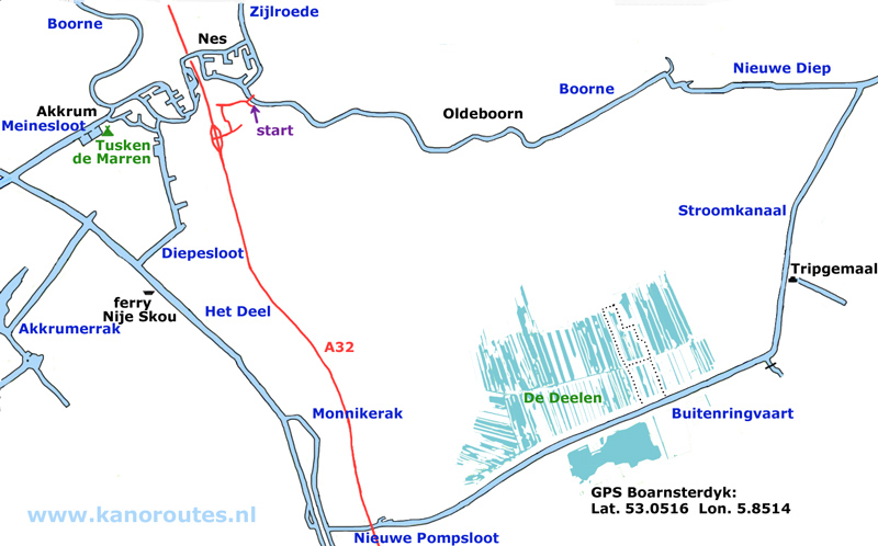
GPS Boarnsterdyk: Lat.: 53.0516 Lon. 5.8514

Water tower of Akkrum.

Moscow 2148 km, New York 5910 km.

Oldeboorn (Aldeboarn).

Oldeboorn (Aldeboarn).

Boorne.

Tripgemaal.

Hiking route in De Deelen.

Peat ship along the Nieuwe Pompsloot.
Grou
A round trip of 20.0 km. to Grou. No portages.
This route goes across lakes and passes the Prinses Margriet Kanaal, so you must have some experience.
Avoid Akkrum on busy days in the high season, or at events like
Skûtjesilen.
From the starting point you go left towards Akkrum and then turn right. You go under the bridge and pass the water-tower. You go straight on. After a short distance you come at a small lake: Bokkumer Mar. You cross the lake and you go straight on. After you pass the sailing school Pean you come at a lake, the Wijde Ee. You go straight on through the passage to the next lake Pikmeer (Pikmar). You keep left in the direction of Grou. Here you have to be careful as is is a busy area. First you cross the Prinses Margriet Canal to get to Grou. Make sure there is enough space from both directions before you cross. At the other side of the canal you turn right and then keep left passed the marina's. Be careful fot boats entering or leaving the marina's. They may make strange moves as sometimes they're not sure where to go. You turn left into the canal. On your left there is a marina for passing vessels with free toilet facilities. You continue on the canal and you pass the church of Grou. You keep going straight on. You go under the bridge of highway A32 and the railroad, and then you're on quiet water. You pass the village Irnsum and then you come at the Prinses Margriet Canal again. Straight ahead you see hotel and restaurant Oude Schouw. There is a pier where you can go to the side. Mind that waves of passing boats may go over the pier. It is possible for kayakers to camp here. At the restaurant you turn left on the Prinses Margriet Canal, and after a short distance you turn right again. You're on the former river Kromme Knillis now, and there are many bends. Just when you think you're near Akkrum, you make another big bend. In Akkrum you see a bridge on your right, but you go straight on. At the next side-canal you turn right on the canal that goes through the village. You go straigt on under the railroad bridge. The canal bends to the left and you keep on the canal. You cross the aqueduct and then the canal goes around Nes. At the T-junction you turn right passed the water tower. At the next T-junction you turn left and after the bridge you're back at the starting point.

GPS Boarnsterdyk: Lat.: 53.0516 Lon. 5.8514

Cargoship on the Prinses Margrietkanaal passing Grou.

Reached the harbour of Grou just before the storm.