

Round trip of 29 km. on the Linde, Tjonger and Scheene.
Three portages (one if you can pass through the locks at Kuinre).Kayak rentals:
- De Kluft, Hoogeweg 26, 8376 EM Ossenzijl (tel.: 0561-477370).
- Kayak Tjonger Tours, Langelille. E-mail: info@kayaktjongertours.nl
Starting point Ossenzijl:
At the bridge across the Linde just outside Ossenzijl. Exit the A50 (Emmeloord-Joure) at Oosterzee and drive to the east through the village Echten. In Echtenerbrug turn right at the T-junction and follow the main road. After a bridge turn left and pass campsite "De Driesprong". At the next T-junction turn right and pass the villages Munnekeburen and Scherpenzeel. After Scherpenzeel you come to a bridge across the Linde. Here you find a kayak-pier just before the bridge on your left.From the starting point you turn right on the Linde. After 8 km. you come at the locks of Kuinre. When they are operated you can pass through for free. If not, portage is about 100 meters under a bridge. There are no kayak-piers but, the sides are not too high. I would have liked to get a cup of coffee here, but unfortunately there's only a pizza delivery that's closed during the day. Across the bridge there is a shop. The locks have an oval shape, maybe because they are in a bend of the waterway. After the locks you turn right on the former river Tjonger. From here it's 4.9 km to the former locks of Schoterzijl. There is a small marina, but bo kayak-pier. The sides are rather high, and if all the mooring places are taken you can not go to the side. One km. further there is a public mooring place on the right. In Langelille you pass a side-arm on the right to a pumping station. A little further there is a mooring place for Tea-garden/café Petra's Sommerkafé. They seem to be opened in the weekends only. You head further north and pass the lake Het Wijd. There are holyday-houses near the bridge. No public pier, the only place where you can go to the side (if no-one is fishing there) is a small place at the bridge. You turn right on the main canal, and then right again on the Jonkersvaart. For some reason it's also called Helomavaart. Some maps mention Jonkers- or Helomavaart. It's a long straight canal. There is an old iron turnbridge, the Oldelamerbrug. There is a pier and you can visit snackbar Snackservice De Jong or Restaurant Snoek (no website). A little further are the locks to the Scheene. The locks are not in use, but there are good kayak piers. There is a picnic table and at the mill De Rietvink there is a teagarden. You head south on the Scheene. After a bridge you turn left and at the end you have to carry the kayak across the road. On the other side you find a kayak pier a little to the right. Follow the main waterway and go straight on to the south. At some point it looks like a dead-end, but there is a narrow passage through the water-plants. After the passage you keep right and follow the pet hole. At the end there is a kayak-pier on your right. You can portage and paddle another 300 meters, or walk from here to pick up your car.
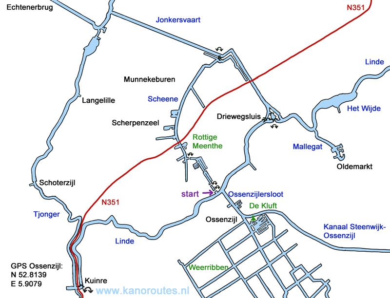
GPS Linde near Ossenzijl: N 52.8139 E 5.9079.
GPS Kuinre: N 52.7869 E 5.8406.

Downloadable GPS-track of 29.2 km.: Kuinre.gpx.

Starting point at the Linde. The reed blocked the passage in 2022. But August 2024 the passage was cleared.

Linde between Ossenzijl and Kuinre.

Linde.

Stork.

Cemetery in Kuinre.

Kuinre.

In the oval locks of Kuinre.

Former locks near Schoterzijl.

Tjonger.

Portage point to the river Scheene.
The cottage by the lock used to be a pub where boaters reportedly spent their last nickel (laatste stuiver).
Now there is Bed and Breakfast accomodation "De Laatste Stuiver".
At the ajecent mill
De Rietvink there is a teagarden.

