

A round trip of 24.5 km. with 3 portages. There are two low passages.
Kayak rentals:
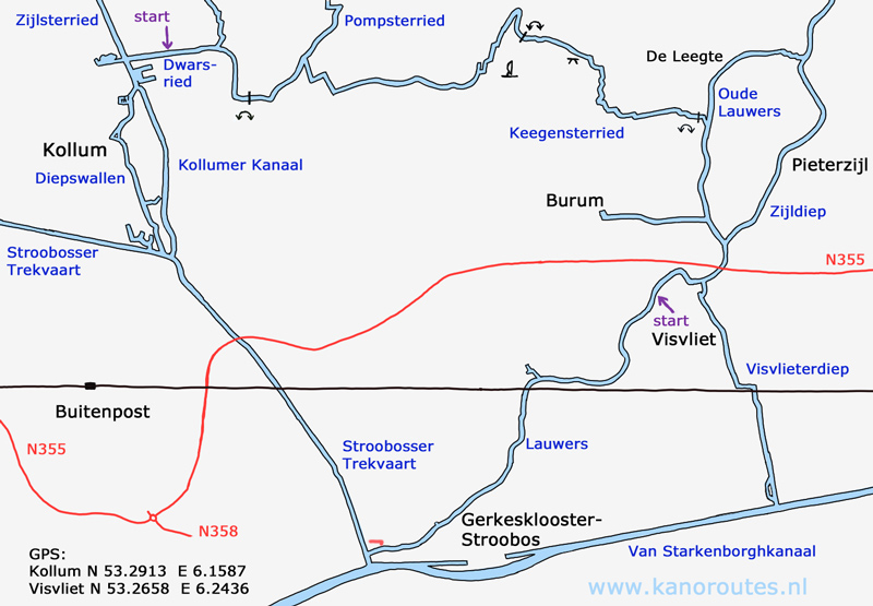
No kayak rentals.To the starting point near Kollum:
From Leeuwarden you go east on the N355. Just before Buitenpost there's a roundabout where you turn left on the N358 towards Lauwersoog. Then at the third roundabout you turn right towards Kollum on the Van Limburg Stirumweg. Keep going straight on. Further on the road is named Tochmalaan and later Willem Loréweg. After a bridge the road bends to the left. The starting point is at the next bridge on your left. Between the bridge of the main road and the bridge of the bike road there is a good spot to launch the kayak.To the starting point Visvliet
Exit the N355 (Leeuwarden - Groningen) at Visvliet. The starting point is at the bridge just west of Visvliet. There is a boatramp, picnic tables, and swimming opportunity. The canal is on the border between the provinces Friesland and Groningen.From the starting point Kollum you head west. You pass the locks that have no function any more and stay open. At the junction you turn left towards Kollum. You turn right and pass marina De Rijd. A little furter you pass a triangular island on the left. You pass through the center of Kollum. The quaysides have been renewed in 2019. You pass the former courthouse "Het Oude Rechthuis". In May 2020 the canal was blocked because of a strutted wall. With care you can pass it by kayak. Outside the town you head south on the Stroobosser Trekvaart for 4.1 km. Just before you come at the Van Starkenborghkanaal you see the dairy factory Campina. You turn left just before the factory. There is a mooring place on the left with a picnic table. You pass Geskesklooster. After a railroad bridge the canal bends to the right. Now the canal is the border between the provinces Friesland (on your left) and Groningen (on your right). Just before Visvliet at the bridge there is a mooring place with a kayak pier on your right. This is the alternative starting point. At the Y-junction you turn left. A little further a sign marks the side canal to Burum. About 1 km further you turn left on the next narrow side canal. After the first bend you come at a weir with iron valves. You have to carry the kayak passed it. This is the Keegensterried. After 1 km there is a bridge with a bike-road. There is a picnic table. With some efford you can go to the side here. A little further there is a sharp bend to the left and you can see the satellite dishes. At a junction you come at the Pompsterried and here you turn left. The next portage is at a pumping station. You have to carry the kayak across a narrow iron bridge passed a gate that can be opened. Launch the kayak on the other side of the pumping station and follow the main canal to the starting point.
GPS:
Kollum, Willem Loreweg: N 53.2913 E 6.1587
Visvliet, Heirweg: N 53.2658 E 6.2435

Downloadable GPS-track (24.5 km): Kollum.

Kollum.

"Het Oude Rechthuis" (former courthouse).

Kollum.

Lauwers near Gerkesklooster.

Lauwers.

Starting point Visvliet. There is a boatramp and swimming facility.

Portage at the beginning of the Keegensterried.

Low passage in the Keegensterried. You have to go trought it as portage is very difficult because of the steep sides, electric fence and curious cows.

Keegensterpad. Bike road between Burum en Warfstermolen. There is a picnic table, but no facilities for kayaks. With a little effort you can on the side.

Satellite earth station JSCU.

Keegensterried at the Brongersmaweg.


