

Eilandspolder
There are 4 marked routes in the area that can be followed in both directions:
- Blue route 21.5 km: Schermerhorn, De Rijp, Graft, De Lei, Noordeinde, Grootschermer, Schermerhorn.
- Red route 6.5 km: De Rijp, Graft, Noordeinde.
- Yellow route 8.5 km.: Grootschermer.
- Green route 7.5 km: Grootschermer.
De route on this page (24.7 km.) follows the blue route with a detour passed West-Graftdijk and a detour passed Driehuizen and through Siberië.
Kayak rentals:
- Café De Vriendschap, Driehuizen 13, Driehuizen. Tel.:0299-672050.
- Camping Tuinderij "Welgelegen", Raadhuisstraat 24a, 1484 EN Graft. Tel: 0299-673032.
- Farm Schermereylandt, Oostdijkje 7 1483 AA De Rijp, Tel: 0299-673757.
Starting point Schermerhorn:
A good starting-point is near Schermerhorn near the Museum Windmill. Coming from Alkmaar on the N243 you pass the exit Schermerhorn and turn right just across the bridge. This is a dead end and there is no sign. There is a parking place to the left. A little further on the dirtroad you see a kayak-pier on your left. This is also is a portage place between the polder and the canal around it.Starting point Driehuizen:
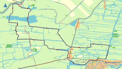
Another good starting point is in Driehuizen. Enter the village across the bridge and then turn right. Just outside the village you see the kayak pier on your left. From this point you can paddle towards De Lei or to the left behind the houses of Driehuizen. Restaurant De Vriendschap can be reached from the water. Their speciality is pancakes.Round trip of 24.7 km. from Schermerhorn (GPS-track)
This tour roughly follows the blue route, but there are a few detours.From the starting point (13) near Schermerhorn you head north under the bridge of road N243. You pass behind the houses and follow the bend to the right (12). You go under the bridge of road N243. Follow the canal along the dike (11). At a junction (10) you turn left and follow the canal next to the dike (09). At a T-junction (06) you turn left and you pass the farm Schermereijlandt where they rent kayaks. At De Rijp you follow the bend to the right and you paddle behind the houses. At (05) you're in the center of De Rijp, and you pass the boat rental place. A little further you turn left under a bridge and then right again. On your left is the island Wollandje. For a visit of De Rijp you can go to the side at the kayak pier on the east side (from the bridge straight on). You head west along the houses of Graft. Follow the bend to the left and at the junction (04) you keep left and head south. Follow the bend to the right and the canal is next to road N244. At the next junction (02) you turn left and pass under the bridge. After the bridge you turn right (30) and follow the canal along road N244. You pass Oost-Graftdijk (31), and you go straight on. A little further the canal bends to the left under a bridge away from the road. Now you're off the beaten tracks. There is an unofficial passage to West-Graftdijk. You take the third ditch to the right. That's where the first houses are. This is shallow water. Follow the bend to the left and you come at a narrow canal through the village. Follow the two bends to the right and you pass the church. When you come at a wide canal you turn left, and right again. If you would go straight on you enter a dead-end canal. Here is a kayak pier for passage to the locks to the Noordhollands Kanaal (25). You go under the bridge of road N244 and follow the main canal. After a bend to the right you turn left. After two bends you turn right at the T-junction. At the next junction (24) you turn left. Now follow the blue route passed (34) to the lake De Lei (02). You head north staright across the lake and enter the canal. After a bend to the left the're shallow water. You pass a kayak-pier (portage point with picnic table) and pass through the village Driehuizen. At a T-junction you turn right and navigate around the grave-yard. At the side-canal to the left is Café De Vriendschap where they rent kayaks. You go straight on and then turn right. When you come at the lake De Lei you turn left and follow the left side. You enter the canal. Now you're off the beaten tracks again. A little further the passage is blocked with wooden obstacles, but it's easy to go to the side and carry the kayak passed it. When you come at a dike you turn right. Follow the narrow ditch along the dike. Further on the water becomes wider and you come at a lake (20). Keep left and go under a bridge. From here you follow the blue route back to the starting point. You go straight on and pass Grootschermer (19). After a bridge you turn left (18). Follow the canal passed the church. After a garden with statues (Museum and Beeldentuin Nic Jonk) you turn right. At the next junction (17) you turn left. There are several side-canals, but just before the end a blue arrow indicates where to turn right. At the next junction (14) you turn left. This canal leads back to the starting point.

Northern part of the Eilandspolder.

Southern part of the Eilandspolder.

Downloadable GPS-track 24.7 km: Eilandspolder25km.
Downloadable GPS-track 10.7 km: Round trip from Driehuizen to Graft-De Rijp.

Starting point at Schermerhorn.

Schermerhorn.

Kayak rental place Schermereijlandt near De Rijp.

West-Graftdijk

West-Graftdijk.

West-Graftdijk.
To enter the polder: You walk past the locks and then turn left to the kayak pier.

Driehuizen.

Boat rental place at Cafe De Vriendschap in Driehuizen.


Grootschermer.


De Rijp.

De Rijp

De Rijp.

Le Cheval Naturellement made by Susan Schildkamp (2012). One of the 10 painted statues of horsen that are scattered throughout the municipality Alkmaar. The project is named "paardenparade", meaning horse parade. This one is situated at the entrance of Graft along the road to West-Graftdijk. There is a kayak pier and a picnic table.

Wollandje. The canal is closed at the spot where the kayak pier once was (situation June 2021). There is a low side a little further where you can go to the side for a visit of De Rijp.

