In the northernmost part of France, about 35 km below Calais you find the marshes and polders of Clairmarais.
It is recognized by the Convention of Ramsar as a protected wetland. It's big enough to make two or three daytrips in the area.
Navigating the waterways is free for unmotorized boats. Access to the water and parking is also free at
Isnor and in Moulle.
Swimming is not allowed.
On this page you find a daytrip of 22 km starting at the kayak rentals of Isnor in the village Clairmarais.
And another daytrip of 16 km that begins in Houlle (no kayak rentals here). No portages at all.
Kayak rentals:
Isnor (Contactform on the website)In September 2012 I visited the Clairmarais in the department Nord Pas-de-Calais with my son. There is a camping site Camping Clairmarais, nearby the starting point at the kayak rentals of Isnor. We stayed at the bed-and-breakfast Pantgat Hof, though. It is situated near Bollezeele, about 20 km from Clairmarais. There are more accomodations in the area. You can find them on www.booking.com. Finding a place to eat is more difficult: during the week most restaurants are closed. And if they're open it's only the bar and they don't serve meals. In Saint-Omer there are some restaurants along the main square in the city center (Place du Maréchal Foch) that are open every day.
Clairmarais
To the starting point near Clairmarais
Coming from the Netherlands, the easiest way is to take the A25 Lille-Dunkerque. Exit at Steenvoorde (13) and head west on the D948 to Cassel, and the the D933 to Saint-Omer. Turn right to Clairmarais (D209). In the village turn right at the church and then left. At the Y-junction turn right.From the A26 (Calais-Arras) take exit 3 and head north on the D942 towards Saint-Omer. In the center you pass the bridge and the reailroad and head north on the D209. In Clairmarais turn left at the church and then left again. At the Y-junction turn right. You see the canal and boat rentals on your left. There is free parking on the grass field along the canal. There are toilets across the street at Isnor and there is a terrace where you can have a drink.
Round trip of 22 km from Clairmarais (Isnor)
From the starting point you head south on the Grande Meer. Just before the bridge you turn right on Le Zieux. Follow the bend to the right and at the T-junction at the end of the canal you turn left twice on the Rivière de Nieurlet. At the end of the canal you turn left on the Y-junction, and then left on the wider Le Grand Leck. After a short distance you turn left on La Grande Clémingue. You cross the main canal and you go straight on at La Petite Cléminge. At the end of the canal you turn right on Le Petit Leck. After a short distance you turn left on Stackelwaert Meer. Follow the main canal and take the 4th side-canal to the right. There is a sharp bend to the left. Then turn right and follow the sharp bend to the right. Take the first side-canal to the left. Follow the sharp bend to the right and then take the 2nd side-canal to the left. You come at the Aa and you see locks on your left. You go straight on at Le Ketestrom. Under the railroad bridge you foolow the bend to the right. Take the second canal to the left (Le Fossé de Église). After a short distance you can go to the side on your left and visit the bird watch cabin. At the end of the canal you turn right on the Narstrom. You go straight on. When the water becomes wider, there is a side-canal to the left towards boat-rentals and a restaurant. You go straight on, and take the next side-canal to the right (sharp right). This is the Ketestrom and you go straight on under the same railroad-bridge as before. Keep left on the Ketestrom. At the main canal Aa you go straight on on the Rivière du Doulac. At the second junction you turn right (Y-junction) and then left again (Grand Zelkewaert). At the T-junction you turn right on Le Petit Leck. Keep going straight on. Go under the two bridges and cross the main canal Aa. Go straight on on the Grande Meer towards the starting point.

GPS Isnor in Clairmarais: Lat. 50.7700 Lon. 2.3003

Route on
Mapmyfitness.
Downloadable GPS-track: GPS/Clairmarais-22km.gpx.

The village Clairmarais.

Footferry at Clairmarais.

Le Zieux.

Rivière de Nieurlet.

Weir along Le Ketestrom.

Narstrom.

Marie-Groette, the witch of the swamp that according to sagas in the area induced disobedient children into the water. The witch looked like a frog and she had a groëtte or grouette (pitchfork) to pull disobedient children into the water. Here she is put up as a scarecrow to protect the area against people who want to bring changes to the area.
Houlle
To the starting point Houlle:
From Watten (along l'Aa) you head south across the bridge. Then turn right in the direction Eperlecques. You pass the Carrefour shopping center (on your left). They have a cheap petrol station. At the roundabout you turn left on the A300. At the next roundabout turn right towards Houlle. At the T-junction in the village you turn right. After a short distance you turn right again. There is a free parking place on your right and at the end is a kayak pier with access to the canal Houlle. Sometimes there are people fishing here. If it's busy you can drive a little further and turn right on the Imp. des Étangs. There ar mooring places with low sides and a boat-ramp where you can go on the canal.From the starting point at the end of the canal Houlle you head north-east. There are a few side-canals, but they're dead ends. After you pass under the bridge of road A300 you turn left on the l'Oveliette. There is a speedlimit sign "6" on the bridge. Follow the narrow canal. It makes a sharp bend to the right. You see a few private lakes on your left that are part of Marais de la Musardière. Then turn left on the canal towards Eperlecques. You go straight on and after a bridge you come at a T-junction. To the left is Eperlecques, but it's a dead end after a short distance. So you turn right along the road towards Watten. Just before the railroad it makes a bend to the left. A little further you turn right under the railroad bridge. This canal becomes narrower. You go under a bridge and after a while you go under a railroad bridge. The canal bends to the left and you keep left on the wider La Haute Reninghe. You come at a T-junction with the main canal Houlle. You turn left and take the second canal to the right. It's just before the bridge where you can see the bigger Canal de Neufossé (also named l'Aa Canalisé). Follow the la Muissens Bras Est along the railroad. After 1.3 km you turn sharp right on the la Muissens Bras Oust and you return to the canal Houlle. Turn left towards the starting point.
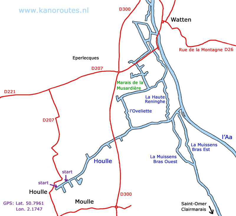
GPS Houlle: Lat. 50.7961, Lon. 2.1747
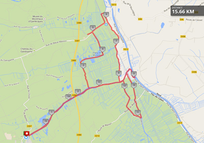
Route on Mapmyfitness.
Downloadable GPX-track: GPS/Houlle-16km.

l'Aa. Commercial ships pass by every now and then and they may cause some waves.

The Houlle.

Houlle: turn left under the bridge on the l'Oveliette.

Watten.

La Haute Reninghe.