Kayak rentals:
Kanoverhuur De Zweth, Zwet 1d, 2295 KZ Kwintsheul, Tel. 0174-290125. It is situated along the Zweth near waypoint 20.

Downloadable GPS-track (19.9 km): Poeldijk.
Poeldijk
A route of 19.9 km including a detour to Loosduinen.Starting point at De Uithof in The Hague.
Exit highway A4 between The Hague and Schiedam at exit 12 (Den Haag Zuid). You head west on the N211 for 6.3 km. Then turn left at the traffic lights towards De Uithof. You go straight on and follow the bend to the right across the tramway. At the end of the road there is a large parking place. To the right is the starting point at kayak club De Windhappers.From the starting point you turn right on the Wennetjessloot. At the T-junction (29) you can turn right for a detour through the park Madestein to Loosduinen. Just follow the bends and the signs towards waypoint 64. You pass the windmill De Korenaer (open on Thursday and Saturday) and the Loosduins Museum. Here I descovered that I had no memory card in my camera... But a little further on there is a small shopping center. At the last bend you can go to the side at the home Brinckhaege. A short distance to the right there is an Albert Heijn supermarket and a number of other shops. At the Blokker I could buy an SD-card :-)
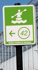
You return the same way and at the junction (29) you go straight on. There is a busy road along the canal, but after a short distance you turn right (43) on the Booma Watering. This is a nice quiet canal as motorized boats are not allowed here. After 4.7 km. you turn left at waypoint 44 on the Gantel. Then after a short distance you turn right at waypoint 45, or as I did, at waypoint 27. Both canals lead to the next waypoints 46 and 47. At waypoint 28 in Honselersdijk you turn left towards waypoint 37. You keep following the canal until a sign shows where to turn left towards waypoint 42. At the next junction you turn left and right again towards waypoint 41. At 41 you come at a wide canal, the Wennetjessloot. Here you turn left towards waypoint 29. On your right is the starting point.
Zwethroute 21.8 km.
Starting point 's-Gravezande:
Starting point on the corner of Julianaweg and Rijnvaartweg in 's-Gravezande. (GPS: N 52.0036, E 4.1714). This starting point is in a park at the end of a small canal. There is free parking space along the main road. There is a snack-bar, but it's closed on Sundays.From the starting point you paddle to the end of the canal, then turn left towards waypoint 34. After a short distance you turn right at the T-junction. Then turn right again at waypoint 23 in the direction of waypoint 22. You keep going straight on and follow the main canal. When the canal is situated along the main road N220 you come at a junction where you see the locks Oranjesluis on your right (waypoint 21). You go straight on towards waypoint 40. After the bridge there is a kayak pier on your right where you can take a break. You pass some houses, and then you take the first canal to the left towards waypoint 19. Follow the bends to the left and right. After the bridge under the main road N213 you turn left. Then take the second canal to the right. After a short distance you come at a small lake (19). Here you turn right towards waypoint 18. On the left side is a kayak pier and a picnic table. You continue through the village De Lier. After you leave the village there is a small marina on your left. After the marina you you turn left towards waypoint 20. This is a wide canal and you keep going straight on passed the huge Trade Parc Westland towards waypoint 32. Follow the bend to the right and then turn left towards Honselersdijk. Keep going straight on and follow the narrow canal passed the road. In the center of the village you turn left under a bridge and then right again towards waypoint 47. Keep going straight on under the N213 towards waypoints 46 and 45. At the end of the canal (45) you turn left at the T-junction on the Gantel. Keep going straight on passed waypoints 44, 35, 25 and 23. At waypoint 34 you turn left, and then turn right again where you return at the starting point.

GPS
's-Gravenzande: N 52.0036 E 4.1714
De Uithof: N 52.0386 E 4.2374

Booma Watering.

Booma Watering.


Honselersdijk.


Poeldijk.

Monster.

Monster, at the themepark De Westlandse Druif. There's no kayak pier here, but with some efford you can go to the side. At the theme-parc there is a terrace along the canal where you can have a coffee.


Oranjesluis.