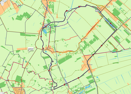
A round trip of 23 km. with 2 portages.
No kayak rentals.
Camping along the Westerwoldse Aa in Wedderveer: Camping Wedderbergen
Starting point at the small harbour at the E. Mulderweg.
Exit the A7 (Groningen - Oldenburg) at Winschoten and head south on the N367 towards Blijham. At Blijham you turn right towards Wedderveer. When you enter Wedderveer you turn left towards the little harbour in the park.Round trip of 23 km.
Leave the harbour and turn left on the Westerwoldse Aa. You can make a small detour following the old bends of the river. You go under a bridge and pass a small harbour on your right. The river becomes wider and looks more like a canal. You pass a kayak-pier on your left and then you turn right on the Veendiep. At Bellingwolde there is a small harbour on your right with a kayak pier. Then you go under a bridge and follow the bends. After a long stretch you come at locks at the end of the canal. The locks are usually open, but if not, there are good kayak-piers. You turn right on the B.L. Tijdenskanaal. This is a wider canal, typical for this part of the country. You come at a weir and locks with kayak-piers on both sides. after the bend to the left you pass a church that houses restaurant Het Moment. A little further on you turn right on the Mussel Aa Kanaal. In Veele you go under 2 bridges and some further on you see a place on our right where you can go to the side. Take out the kayak and cross the dirt road towards the Ruiten Aa. Follow the many bends towards the first weir. After the weir the river joins with the Mussel Aa. From here the river is named Westerwoldse Aa. The river is wider here and there are no more bends. After a second weir you pass Wedde and you head north towards Wedderveer.Ruiten Aa.
In 2008 the Ruiten Aa was brought back to its original meanders. In 2009 the part between the Mussel Aa Kanaal and the bridge at Smeerling was opened for kayaks. This is only 1.4 km. But if the water-level is high enough you can go a lot further. The rivers becomes narrow and there are many sharp corners (not yet visible on Google Earth). Also water-plants make it difficult to pass at some places. The weirs can be passed if you stay in the middle of the river.
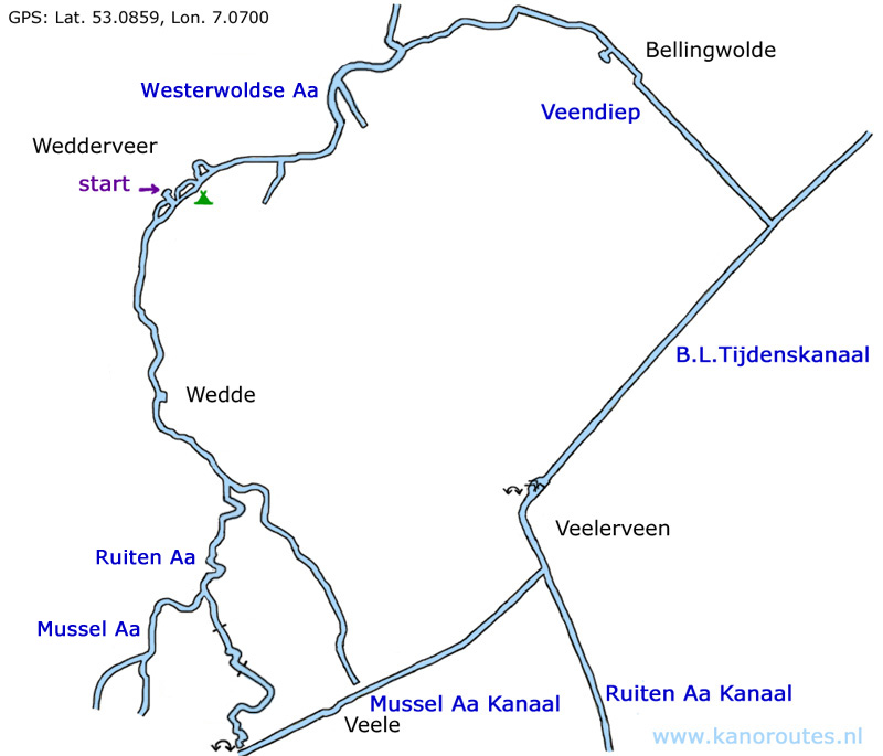
GPS: Lat. 53.0859 Lon. 7.0700
Downloadable GPX-track: Wedderveer.

View from the locks in the Veendiep.

Veendiep. At the locks to the B.L. Tijdenskanaal.

Locks at Veelerveen.

Mussel Aa Kanaal. On the right is the portage place to the Ruiten Aa. To the left portage towards Smeerling (1.4 km).

Portage to the Ruiten Aa. There is a small floating kayak pier.

A tree blocks the passage in the Ruiten Aa. You need to step on it and pull the kayak across.

Ruiten Aa.

Ruiten Aa.

Ruiten Aa.

Back in Wedderveer.

Ruiten Aa south of Smeerling.