

Round trip around Oudorp: 9 km.
Kayak rentals:
- In the center of Alkmaar: De Kraak, Verdronkenoord 54, Alkmaar. Tel.: 072-5125840.
- During the summer also from Poldermuseum Heerhugowaard.
Camping Alkmaar: 500 meter van de Ringvaart Bergermeer
Starting point along the Hoornse Vaart:
From the beltway (Ring) N508 you exit at the traffic lights in the direction Oudorp. Just before the bridge you turn right. There is a free car park on your right and you'll find a kayak pier at the canal.From the starting point you paddle west in the direction Alkmaar. Follow the canal and pass Oudorp. You'll pass several windmills and when you enter Alkmaar you come to a bigger canal, the Noordhollands Kanaal. Give way to all motorized ships here, and be prepared to meet some waves. Turn right at the canal. When you see a white building in front (Police station) keep to the left. At the end turn left under the bridge. Here you enter the Singel. When you see a wooden bridge in front, you must turn left under a narrow bridge Lamoraalsluis. When you passed another bridge you come to a canal named Oudegracht. Keep going straight on. At the end the canal makes a turn to the left and you pass a bridge named Turfmarktbrug. Here you come into the Noordhollands Kanaal again. You can turn right here to continue your trip, or make a detour trough the city center. If so, go straight on and turn left under the second bridge (there is a small ferry for pedestrians here). At the end of the canal you come at the weigh-house where the cheese-market is held on Fridays. Here you turn right and when you come back into the Noordhollands Kanaal turn right again. Pass the bridge Frieschebrug, and you come at the point where you started the detour. From here, follow the main canal to the east. When the Noordhollands Kanaal turns right (there is a shipyard on the left corner), you turn left. Just follow the canal and you'll return to the starting point.
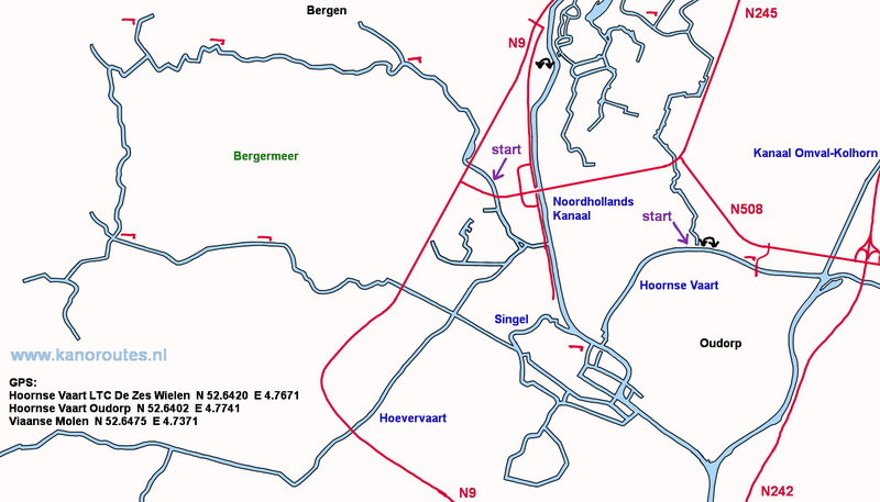
GPS:
Hoornse Vaart LTC De Zes Wielen N 52.6420 E 4.7671
Hoornse Vaart Oudorp N 42.6402 E. 4.7741
Viaanse Molen N 52.6475 E. 4.7371

Overstad.

Police station at the peninsula Afgesneden Kanaalvlak.

Bergerbrug.

Singel.

Lindegracht.

The Hameipoort dates from 1725 and was restured in 2015.

Excise Tower.

Kooltuin.

Weighing tower De Waagtoren.

House with the Cannon Ball.
The year 1573 was a turning point in the siege of Alkmaar (Eighty year's war with Spain).

Gewelfde Stenenbrug.
