

Kayak rentals
Landschap Noord-Holland, Kanaaldijk 32A, 1121 NX Landsmeer.Just outside the city limits of Amsterdam there is a remarkable silent area. There is no tourism, and except a few narrow roads there's hardly any traffic. For kayakers an ideal environment. But on the downside, there are few facilities. At most places it is not allowed the enter the land. It is protected area, or private property. Just outside Landsmeer you pass a Mc Donalds though. In Zunderdorp there's no kayak pier. In Ransdorp there is a kayak pier at the church (no shops here). In Holysloot there is a footferry where you can buy icecream, beer or cola when the ferry operates.
To the starting point Landsmeer:
Exit the beltway around Amsterdam A10 at exit 17 towards Landsmeer. Follow the main road north through the center. Turn left on the Sportlaan. There is a sign that directs to the sport location with the same name. On your right you see a free parking place. There is a boatramp and a kayak pier.Round trip of 28.2 km. as seen on the GPS-track
Without the detour to Zunderdorp, the distance is 26.6 km.From the starting point you head to the right. After the appartment-houses there is a canal to the right. Follow the canal and pass under a bridge. When you come at a main canal you turn right. You go straight on under a bridge and cross the Noordhollands Kanaal. After a bend to the left you come at an intersection. You go straight on (30 degrees to the right) and after a short distance you come at a lake. Cross the lake (on your left you see a kayak pier where you can take a break) and enter the canal. At the next intersection you turn left. On your right you see Landsmeer. You go straight on. After a bridge you turn right and left again. You go under the bridge of the Amsterdam beltway. On your right you see Mc Donalds. There is no pier, but it is possible to go to the side here. You go straight on and at the next intersection you turn left. Then you turn left again and after you passed under the highway you turn right again. The straight canal runs along the highway and ends at the Noordhollands Kanaal. Here you turn left. After a short distance the first canal to the right is closed, so you have to take the second one sharp right and paddle around the island. Then turn left under the culvert under the N 247. Just after the bridge you turn right and follow the main canal along the dike. At the wide canal to the left towards Zunderdorp you go straight on. Here you can trun left for a visit to the village. There's no kayak pier there. Then you continue straight on. After the bridge you turn left. At the end of the canal you go under a bridge and turn left at the T-junction. You go straight on towards Ransdorp. Take the narrow canal to the left of the church. At the church there is a kayak-pier. At the T-junction you turn left. This is a narrow bend, not suitabale for canoes longer than 7 meters. You go under another low bridge and then the canal widens. At the end of the village you take the first canal to the left. You go under a bridge and continue straight on towards the lake Ransdorper Die. Follow the lake to the right. On the other side at the northern point there is a canal that leads to the next lake, the Holysloter Die. Follow the lake and you see Holysloot on your right. Then follow the left side and take the first canal to the left. Follow the canal and you pass a wooden lift-bridge. Then you come at another lake, the Bozen Meertje. You go across enter the canal. Keep following this canal till you reach the first houses of Broek in Waterland. You go under a bridge and turn right. At the end of the canal you come at road N247. Turn left at the T-junction and then follow the bend to the right under a bridge. Keep left and enter the canal Broekervaart. After 1.4 km you come at a side-canal and you turn right. A little further there is a footbridge with a kayak pier and a picnic table. You go straight on and then take the first canal to the left. Then at the second intersection you turn left again. After a high footbridge you turn right. You go straight on and cross the Noordhollands Kanaal. At the next intersections you follow the main canal. You come at a lake and you cross is a bit to the right to a short canal. At a main canal you turn right and then left again towards Landsmeer. After a bridge you come at a lake. Head to the left back to the starting point.
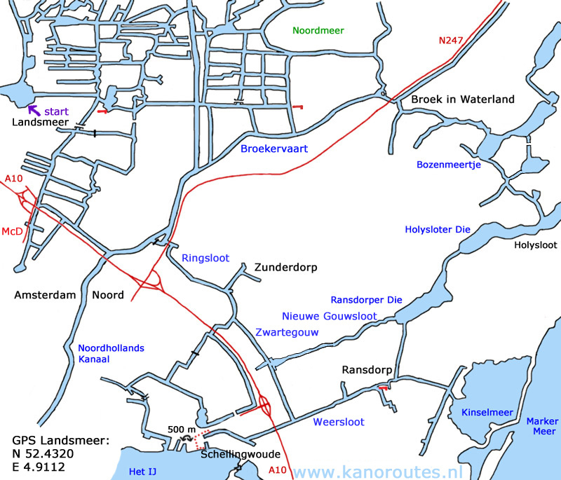
GPS Sportlaan Landsmeer: N 52.4320 E 4.9112

Downloadable GPS-track (28.2 km including Zunderdorp): Landsmeer.

Landsmeer.

Zunderdorp.

Zunderdorp.

Zunderdorp.

Zwartegouw.

Zwartegouw.

Ransdorp. There is a kayak-pier at the church.

Footferry at Holysloot.

End of the canal at Schellingwoude. Here you can go to the side and portage to Het IJ.


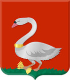 The weapon of Ransdorp shows a swan with a golden collar. It holds six arrows symbolising the villages in Waterland.
In 1921 Ransdorp was annexated by the city of Amsterdam, and the weapen was no longer in use.
The weapon of Ransdorp shows a swan with a golden collar. It holds six arrows symbolising the villages in Waterland.
In 1921 Ransdorp was annexated by the city of Amsterdam, and the weapen was no longer in use.