Round trip of 30.5 km. A shorter trip is also possible.
This trip can not be made from March 30 till June 30 because the Landscheiding is closed during the breeding season.Kayak rentals:
Kanocentrum Loetbos, Loet 4, 2941 LB Lekkerkerk. Tel.: 06-83401209.
When driving on the beltway around Rotterdam it is hard to imagine there is an area nearby with abosulute silence except for some birds.
But there really is, and it's large too. Only recently the area was made accessible for kayaks.
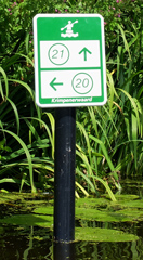
Signs with numbered waypoints mark the intersections and other signs direct to the numbered waypoints.
Many low bridges werd made higher and new kayak piers were made wherever portage is necessary. The network was officially opened July 15, 2015.
On the first of August I made a big round trip of 30.5 km. covering most of the new kayak routes. There were no footsteps on the fresh sand, so I guess I was the first...
And I must say, this is a beautiful area way above expectations!
There are a few things that can be improved: The marker of waypoint
07 is misplaced. You end up in a narrow ditch blocked by a dike. The real turning point is 100 meters further east.
You need to portage at the former locks of Berkenwoud, but the kayak pier is difficult to access. The pole with the sign is placed just before it, and there are remains of an old kayak pier partly under water just before the new pier.
The canal between wayponts 8 and 2 is also part of the new network,
but is not mentioned on the information signs. The canal is closed for public during the breeding season from March 30 till June 30.
Starting points.
I made a trip starting at restaurant "Plus Breeka" Waypont 20). It is situated along road N210 Krimpen aan de IJssel towards Bergambacht. There is a parking place at the kayak pier. The area behind the restaurant is private for truck parking.Alternative starting point is at Achterbroek (waypoint 9): P Elzerkade. There is a small parking place.
Or just south of Stolwijk (waypoint 3). There is a new parking place along road N207).
The struggle to keep the feet dry.
About 10,000 years ago the peatswamp came to exist. The rivers Hollandse IJssel and Lek meandered through it. Until about the year 1000 no people lived in the area. The swamp was flooded from time to time. But when the first people came they settled on a few sandhills and along the rivers. They tried to cultivate the land and started building dikes. But because the peat was made dry, the soil began to lower and a struggle that still goes on to-day was started. As the land lowered, higher dikes had to be made. It is expected that in the year 2050 the soil will be 50 to 70 cm. lower than to-day if nothing is done. The only solution seems to be to keep the water level high. But this is a problem as to-day many people live in the area.Route of 30.5 km from waypoint 20.
From the starting point you head east. You come at a small lake with a bridge across it. You turn right and left again. After a short distance you turn left. This is a narrow shallow canal. After a short distance you turn right and you're back on De Loete. At waypoint 17 you go straight on towards waypoint 16. You pass Kanocentrum Loetbos. At waypont 16 you have to portage to the new canal on the left. There is a picnic table.You turn right on the Ringvaart at the sign that directs to waypoint 7. Follow the bend to the left and turn right at the sign. You come at the former locks of Berkenwoud. After the locks you have to portage. At waypoint 7 you turn left towards waypoint 8. At waypoint 8 you turn right on the long Lanscheiding. There are many side canals, but you keep going straight on to the end of the canal. At waypoint 8 you turn right towards Stolwijk. I experienced a lot of duckweed here. It slows you down some. In Stolwijk you go under two bridges and you keep going straight on. You pass waypoint 3. After some distance you have to turn left and right again under a narrow and low bridge. With the kayak you can go under it, but it may be difficult with an open canoe. There are kayak piers, so portage is also possible. At the T-junction (waypoint 4) you turn right on the long straight canal. Just before the bridge of a bike-road you turn left and portage to the Reevliet (waypoint 6). Turn right and follow the bend to the left.
At the end of the canal you have to portage again (waypont 13). When you come at the Loetbos you take the southern passage (waypoint 18). Keep going straight on and pass waypoint 17. At the sign you turn left towards waypoint 19 on the narrow canal. From the small lake with the bridge across it you continue on the northern passage back to the starting point (waypoint 20).

GPS "Plus Breeka" near Krimpen aan de IJssel (Waypoint 20): Lat. 51.9127, Lon. 4.6420
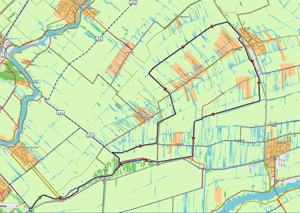
Downloadable GPX-track: Krimpenerwaard.

Starting point near Krimpen aan de IJssel.

Loetbos.

Loetbos.

Loetbos.

Outside the main route the water may be shallow, and because of the duckweed you can't see obstacles below the water-line.

Krimpenerwaard.

Berkenwoud.

Krimpenerwaard. Sidecanal of the Landscheiding.

Stolwijk.

Stolwijksche Vaart.