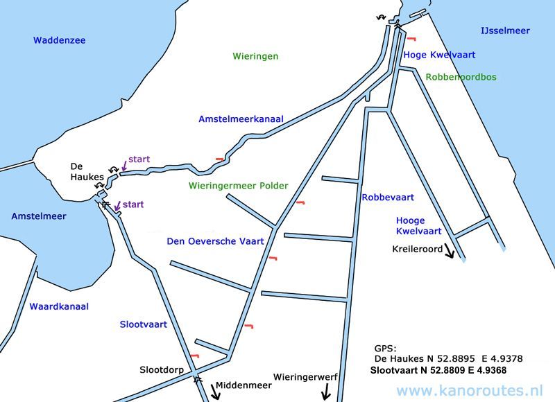
Distance: 8.5 km to the end of the Amstelmeerkanaal x 2 = 17 km.
A round trip passed Slootdorp is 24.2 km including a 700 meter portage.
No kayak rentals.
Until 1924 Wieringen was an island. Then the dikes of the polder Wieringermeer were made. After the polder was made the Afluitdijk was built in 1932 and connected the former island with Friesland. On the south-side there is the polder Wieringermeer, and in between is a canal, the Amstelmeerkanaal.
Starting point De Haukes
Leave the N99 (Den Helder - Den Oever) at the roundabout in the direction De Haukes (N240). You pass through the village and turn left in the direction Slootdorp. At the end of the village the end of this route is on your left. For a round trip you drive 1 km further, and you turn right at the crash barriers. Just before the trees there is a side-canal of the Slootvaart. On the corner there is a low side where you can launch the kayak.
Round trip of 24.2 km.
At the locks Haukessluis you can pass through the locks. Have a look at the website for further information. Without passing through the locks you can make a round trip of 24.2 km. but you add 1.1 km. for walking to your car. At the locks portage is not possible.The first possible starting place is at a side-arm of the Slootvaart. On the corner there is a low side where you can get in.
From the starting point you head south towards Slootdorp. At Slootdorp there is a fishing pier with a low side for kayaks. A little further you turn left before the locks. Along the Den Oeversche Vaart there are three kayak piers. At the end of the canal there is a pier on the left, but as it rather high you can not use it. The second pier is private property. So here you have the option of either pass through the locks Stontelersluis or make a detour with two portages. On you right there is a kayak pier. From here you can cross the peninsula. On the other side you turn right on the canal Hoge Kwelvaart for a short distance. Then you go on the side at a kayak pier on you left. In the past there was a campsite here. It no longer exists, but the kayak pier is still there. Follow the path to the left through the woods Robbenoordbos. You turn left at the paved road and cross the bridge at the locks. Then you pass through the bike-tunnel under highway A7. If you have passed through the locks, you turn left. At the pumping station there is a concrete edge where you can go to the side.
In 2025 a new kayak pier was made along the Wieringerrandweg. You can get in here to continue on the Amstelmeerkanaal. From here it is 8.5 km. to De Haukes. There are new kayak piers here. You can portage tot the last piece of canal before the lake Amstelmeer, or go to the side and walk to the starting point of this route. At the end of the short canal there is a kayak-pier. There's no kayak-pier in the marina, but there is a concrete edge where you can get in.
Despite the long straight canals this is a very nice route. You can enjoy the silence as not many boaters come here. The woods Robbenoordbos are a nice variation. If you can pass through the locks, there's only a short portage of 50 meters to the Amstelmeerkanaal. If not, you have to take the 'scenic route' with a portage of 700 meters. I recommend you use a canoe-cart then.
GPS:
De Haukes: N 52.8895 E 4.9378
Slootvaart: N 52.8809 E 4.9368
Den Oever: If you pass through the locks you turn left and go under two bridges.
At the pumping station you can to on the side on the left.
There is a low concrete edge.
For a portage of 700 meters you go to the side on the kayak-pier on the right.
Then portage to the other canal. Paddle a short distance to the right and then go to the side on the left.
Turn left on the paved path and then turn left when you come at the road.
Then you go straight on following the bike-tunnel under highway A7.
Passed the pumping station there is a new kayak pier along the Wieringerrandweg.
From here you can continue on the Amstelmeerkanaal.

Downloadable GPS-track of 24.2 km. Wieringen.

Slootvaart with a kayak-pier on the left.

Kayak-pier along the Slootvaart.

Locks in Slootdorp.

Kayak-pier along the Den Oeversche Vaart.

Den Oeversche Vaart.

Marina in the Robbenoordbos.

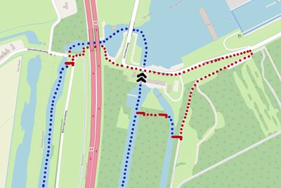
Passage under highway A7.

Locks Stontelersluis and pumping station Leemans.
You can pass through the locks to the Binnenhaven/IJsselmeer.
The new black pier on the left is public, but it's too high for kayaks,
and the second pier is private.
On the right there is a kayak-pier where you can portage to the Hooge Kwelvaart.
Here you also find a kayak-pier.

On the Hoge Kwelvaart you paddle a short distance to the right.
After the bend you see this kayak-pier on your left. Here you can go to the Robbenoordbos.

Portage via the Robbenoordbos to the Amstelmeerkanaal (700 meters).

Portage on the road across the locks passed the pumping station Leemans.

You pass through the bike-tunnel to the Amstelmeerkanaal.

If you can pass through the locks, you can portage here from the harbor Binnenhaven to the Amstelmeerkanaal.

Kayak pier at the eastern end of the Amstelmeerkanaal.

Kayak pier and picnic table at the bike-path across the Amstelmeerkanaal.

De Haukes.